Missouri River

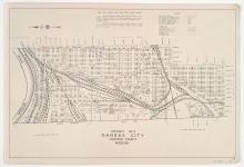
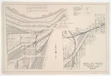
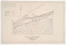
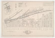
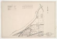
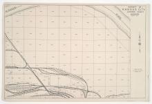
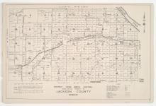
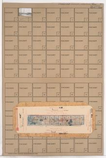
District No. 30 North Map (Range 32, Townships 50 & 51), Jackson County, Missouri

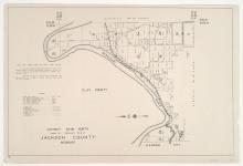
Detail map of the northern section of District 30 of the 1940 tax assessment project. Map illustrates block numbers, appraised values, and plat boundaries, as well as streets and railroads. The map covers an area of north-central Jackson County, Missouri, south of the Missouri River and west of present day Highway 291.

District No. 3 Map, Kansas City, Jackson County, Missouri

Detail map of District 3 of the 1940 tax assessment project. Map illustrates block numbers, appraised values, and plat boundaries, as well as railroad lines, streets, and rivers. The map covers an area from the Missouri River south to 31st Street (west of Summit Street) and 25th Street (east of Summit Street), and from the Kansas state line east to Broadway Boulevard (north of 25th Street) and Summit Street (south of 25th Street).

District No. 3 Industrial Map, Kansas City, Jackson County, Missouri

Detail map of two industrial areas in District 3 of the 1940 tax assessment project. Map illustrates block numbers, appraised values, and plat boundaries, as well as railroad lines, streets, and rivers. The map on the left covers an area of the West Bottoms Industrial District from the Missouri River south to 14th Street and from the Kansas state line east to Beardsley Road, Bluff Drive, and Broadway Boulevard. The map on the right pictures blocks adjacent to Southwest Boulevard, from as far north as 21st Street and as far south as 31st Street.

District No. 2 South Industrial Map, Kansas City, Jackson County, Missouri

Detail map of the southern industrial section of District 2 of the 1940 tax assessment project. Map illustrates block numbers, appraised values, and plat boundaries, as well as railroad lines, streets, bridges, and rivers. The map covers an area from the Missouri River south to 5th Street and Independence Avenue, and from Broadway Boulevard east to Troost Avenue.

District No. 2 South and West Maps, Kansas City, Jackson County, Missouri

Detail maps of the southern and western sections of District 2 of the 1940 tax assessment project. Maps illustrate block numbers, appraised values, and plat boundaries, as well as railroad lines, bridges, streets, and rivers. The southern map covers an area from the Missouri River and Rochester Avenue south to Independence Avenue, and Delaware Ave east to Troost Avenue; and the western map covers an area from the Missouri River south to 5th Street, and Broadway Boulevard east to Delaware Street.

District No. 60 North Central (Ranges 29 & 30, Township 50) Map, Jackson County, Missouri

Detail maps of the north central section of District 60 of the 1940 tax assessment project. Map illustrates block numbers, appraised values, and plat boundaries, as well as streets, railroads, and rivers. Map covers an area of northeastern Jackson County, east to the Lafayette County line and north of Burgess and Doris Neeb Roads, and including the city of Buckner.

Tax Assessment Block Folder, Kansas City, MO, District 2, Block 224

Folder contains a photograph of a Kansas City Gas Company building in the East Kansas addition, from Front Street south to 1st Street, and Campbell Street east to Gillis Street. The A.S.B. Bridge can be seen in the background of the image. Folder also contains plat map of the block.

Tax Assessment Block Folder, Kansas City, MO, District 2, Block 218

Folder contains photographs of industrial buildings in an area of Northeast Kansas City between the Missouri River and the rail lines, 1st Street, and Front Street, and spanning from the Hannibal Bridge to the A.S.B. Bridge, which can be seen in the background of one of the images.