Southview

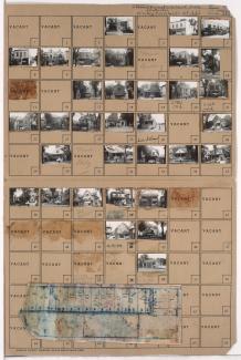
Tax Assessment Block Map, Kansas City, MO, District 11, Block 10

Map of block in the Old Hyde Park neighborhood, from 31st Street south to Linwood Boulevard, and Main Street east to McGee Street, including sections of 31st Terrace and Grand Avenue, containing information about tax assessment values of included properties, and illustrating lot numbers for the block. Photographs of properties on the block can be viewed below.

Tax Assessment Block Folder, Kansas City, MO, District 11, Block 10

Folder contains photographs of residences, businesses, and apartment buildings in the Old Hyde Park neighborhood, from 31st Street south to Linwood Boulevard, and Main Street east to McGee Street, including sections of 31st Terrace and Grand Avenue. Folder also includes a plat map of the block, which can be viewed below.

Tax Assessment Block Folder, Kansas City, MO, District 11, Block 9

Folder contains photographs of residences, businesses, and other buildings in the Old Hyde Park neighborhood, from 31st Street south to Linwood Boulevard, and McGee Street east to Oak Street. Linwood Ice Cream, at 3100 Oak, is among the buildings pictured. Folder also includes a plat map of the block.