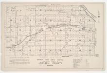
Districts No. 61-64 Maps and District 60 Platted Area Maps 60 A-A, B, C, F, & I Kansas City, Jackson County, Missouri
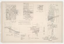
Small detail maps of Districts 61 through 64, and platted areas A-A, B, C, F, and I in District 60 in southwestern Jackson County, Missouri. Maps illustrate block numbers, appraised values, and plat boundaries, as well as streets, railroads, and lakes. Map of District 61 and 60B cover the Buckner area. Map of District 62 covers the Grain Valley area. Map of District 63 and 60A-A cover the Levasy area. Map of District 64 covers the Oak Grove area. Map 60C covers the Lake City area. Map 60F covers the Tarsney Lakes area. Map 60I covers the Lone Jack area.