Jackson County, Missouri

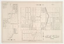
District No. 30 South Platted Area Map A Map, Jackson County, Missouri

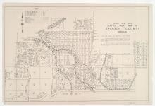
Small detail map of platted area "A" of the southern half of District 30 in Jackson County, Missouri. Map illustrates block numbers, appraised values, and plat boundaries, as well as streets and railroads. The map covers an area of north-central Jackson County, Missouri, northwest of Independence's 1940 city limits, from roughly Evans Street south to Van Horn Road, and from Kansas City's 1940 city limits east to Forest Avenue south of 24 Highway and Crysler Avenue north of 24 Highway.

District No. 30 North & South Platted Area Maps C, D, & DD, Jackson County, Missouri

Small detail maps of platted areas C, D, and DD of District 30 in Jackson County, Missouri. Maps illustrate block numbers, appraised values, and plat boundaries, as well as streets and railroads. Map C covers an area northeast of Sugar Creek's 1940 city limits, from Hocker Avenue south to Sugar Creek Road, and from Culver Avenue east to Jones Street. Map D covers an area north of the 1940 Independence city limits, from Lacey Avenue south to Leslie Avenue, and Englewood Avenue east to Blue Springs Road/Alton Avenue. Map DD covers a small area adjacent to U.S.

District No. 20 North Platted Area Maps G, J, K, & KK, Jackson County, Missouri

Small detail maps of platted areas G, J, K, and KK of the northern half of District 20 in Jackson County, Missouri. Maps illustrate block numbers, appraised values, and plat boundaries, as well as streets and railroads. Map G covers a large area of present day Kansas City, from 77th Street south to 89th and 91st Streets, and from the Kansas state line east to The Paseo. Map J covers an area from Swan Street south to Henry Street, and Indiana Avenue east to Cleveland Avenue.

District No. 20 North Platted Area Maps A-F & H, Jackson County, Missouri

Small detail maps of platted areas A through F and H of the northern half of District 20 in Jackson County, Missouri. Maps illustrate block numbers, appraised values, and plat boundaries, as well as streets and railroads. Map A covers an area from Topping Avenue east to Eastern Avenue, and 47th Street south roughly to 52nd Street. Map B covers an area east of Bennington Avenue, adjacent to U.S. Highway 50 and Harris Road/55th Street. Map C covers a small area around the intersection of Topping and 63rd Street.

District No. 60 North Central (Ranges 29 & 30, Township 50) Map, Jackson County, Missouri

Detail maps of the north central section of District 60 of the 1940 tax assessment project. Map illustrates block numbers, appraised values, and plat boundaries, as well as streets, railroads, and rivers. Map covers an area of northeastern Jackson County, east to the Lafayette County line and north of Burgess and Doris Neeb Roads, and including the city of Buckner.