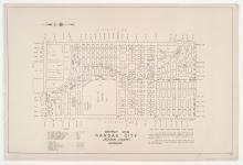
District No. 20 North Platted Area Maps A-F & H, Jackson County, Missouri
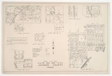
Small detail maps of platted areas A through F and H of the northern half of District 20 in Jackson County, Missouri. Maps illustrate block numbers, appraised values, and plat boundaries, as well as streets and railroads. Map A covers an area from Topping Avenue east to Eastern Avenue, and 47th Street south roughly to 52nd Street. Map B covers an area east of Bennington Avenue, adjacent to U.S. Highway 50 and Harris Road/55th Street. Map C covers a small area around the intersection of Topping and 63rd Street.