
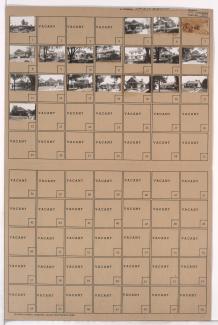
Folder contains photographs of residences in the Neighbors United for Action neighborhood, from 68th Terrace south to 69th Street, and Woodland Avenue east to Paseo Boulevard.
Folder contains photographs of residences in the Neighbors United for Action neighborhood, from 68th Terrace south to 69th Street, and Woodland Avenue east to Paseo Boulevard.
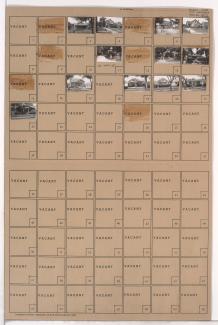
Folder contains photographs of residences and businesses in the Tri-Blenheim neighborhood, from 69th Street south to 69th Terrace, and Olive Street east to Prospect Avenue. Velvet Freeze Ice Cream, at 69th and Prospect, is among the buildings pictured.
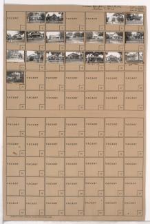
Folder contains photographs of residences in the Neighbors United for Action neighborhood, from 69th Street south to 69th Terrace, and Woodland Avenue east to Paseo Boulevard.
Folder contains photographs of residences in the Neighbors United for Actions neighborhood, from 69th Terrace south to 70th Street, and Woodland Avenue east to Paseo Boulevard.

Folder contains photographs of residences in the Armour Hills neighborhood, from 69th Street south to 69th Terrace, and Brookside Road east to Main Street. Folder also includes a plat map of the block.

Folder contains photographs of residences in the Armour Hills neighborhood, from 69th Terrace south to 70th Street, and Brookside Road east to Main Street. Folder also includes a plat map of the block.

Folder contains a photograph of the J. C. Nichols School in the Holmes Park neighborhood, from 69th Street south to 69th Terrace, and Oak Street east to Cherry Street. J. C. Nichols School is located at 6903 Oak.

Folder contains photographs of residences in the Armour Hills neighborhood, from 69th Street south to 69th Terrace, and Main Street east to Grand Avenue and Rockhill Road. Folder also includes a plat map of the block.

Folder contains photographs of residences in the Armour Hills neighborhood, from 69th Terrace south to 70th Street, and Main Street east to Rockhill Road. Folder also includes a plat map of the block.

Folder contains photographs of residences in the Armour Hills neighborhood, from 69th Street south to 69th Terrace, and Rockhill Road east to Oak Street. Folder also includes a plat map of the block.

Folder contains photographs of residences in the Armour Hills neighborhood, from 69th Terrace south to 70th Street, and Rockhill Road east to Oak Street. Folder also includes a plat map of the block.

Folder contains photographs of residences in the Holmes Park neighborhood, from 69th Terrace south to 70th Street, and Cherry Street east to Oak Street. Folder also includes a plat map of the block.

Folder contains photographs of residences in the Holmes Park neighborhood, from 69th Street south to 69th Terrace, and Cherry Street east to Holmes Road. Folder also includes a plat map of the block.

Folder contains photographs of residences in the Holmes Park neighborhood, from 69th Terrace south to 70th Street, and Cherry Avenue east to Holmes Road. Folder also includes a plat map of the block.

Folder contains photographs of residences in the Armour Fields neighborhood, from 69th Terrace south to Romany Road, and Ward Parkway east to Valley Road.

Folder contains photographs of residences in the Armour Fields neighborhood, from Arno Road and 69th Street south to 69th Terrace, and Ward Parkway east to Valley Road. Folder also includes a plat map of the block.

Folder contains photographs of residences in the Armour Fields neighborhood, from 69th Street south to 69th Terrace and Valley Road east to Pennsylvania Avenue.

Folder contains photographs of residences in the Armour Fields neighborhood, from 69th Terrace south to Romany Road, and Valley Road east to Pennsylvania Avenue.

Folder contains photographs of residences in the Romanelli West neighborhood, from 67th Street south to Gregory Boulevard, and State Line Road east to Ward Parkway, including sections of Arno Road, 69th Terrace, Romany Road, 70th Street, and 70th Terrace.