
First of two folders containing photographs of residences and other buildings in the Eastwood Hills neighborhood, south of 40th Street, and from Ewing Avenue east to the Kansas City city limits.
First of two folders containing photographs of residences and other buildings in the Eastwood Hills neighborhood, south of 40th Street, and from Ewing Avenue east to the Kansas City city limits.

Second of two folders containing photographs of residences and other buildings in the Eastwood Hills neighborhood, south of 40th Street, and from Ewing Avenue east to the Kansas City city limits.

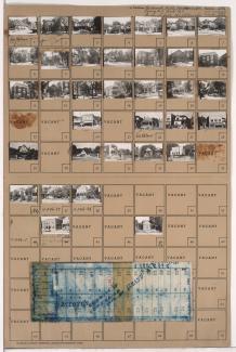
Folder contains photographs of residences in the Vineyard Northwest neighborhood, from 40th Street south to 41st Street, and Spruce Avenue east to Kensington Avenue. Folder also includes a plat map of the block.

Folder contains photographs of residences in the Vineyard neighborhood, from 40th Street south to 41st Street, and Kensington Avenue east to Cypress Avenue. Folder also includes a plat map of the block.

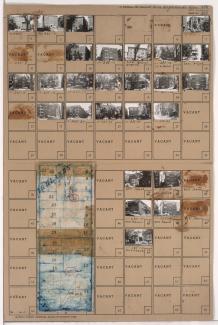
Map of block in the Vineyard Northwest neighborhood, from 41st Street south to 43rd Street, and Jackson Avenue east to Spruce Avenue, containing information about tax assessment values of included properties, and illustrating lot numbers for the block. Photographs of properties on the block can be viewed below.

Folder contains photographs of residences and other buildings in the Vineyard Northwest neighborhood, from 41st Street south to 43rd Street, and Jackson Avenue east to Spruce Avenue. Folder also includes a plat map of the block, which can be viewed below.

Folder contains photographs of residences and other buildings in the Vineyard neighborhood, from 41st Street south to Towers Road; and Spruce Avenue east to Cypress Avenue. Folder also includes a plat map of the block.

Folder contains photographs of residences in the Vineyards Northwest neighborhood, from 40th Street south to 41st Street, and Norton Avenue east to Jackson Avenue. Folder also includes a plat map of the block.

Folder contains photographs of residences in the Vineyards Northwest neighborhood, from 40th Street south to 41st Street, and Myrtle Avenue east to Norton Avenue. Folder also includes a plat map of the block.

Folder contains photographs of residences in the Vineyards Northwest neighborhood, from 40th Street south to 41st Street, and Cleveland Avenue east to Myrtle Avenue, including a section of Mersington Avenue. Folder also includes a plat map of the block.

Folder contains a photograph of the Gillham Park Maintenance Building at 39th and Gillham. Folder covers a block in the South Hyde Park neighborhood from 39th Street south to 43rd Street, and Gillham Road east to Kenwood Avenue. Folder also includes a plat map of the block.

Folder contains photographs of residences in the Southmoreland neighborhood, from 40th Street south to 41st Street, and McGee Street east to Oak Street.

Folder contains photographs of residences and apartment buildings in the Southmoreland neighborhood, from 40th Street south to 41st Street, and Main Street east to Walnut Street. St. Paul's Episcopal Church, at 40th and Main, and Rollins School, at 4043 Main, are among the buildings pictured. Folder also includes a plat map of the block.
Folder contains photographs of apartment buildings in the Southmoreland neighborhood, from 40th Street south to 41st Street, and Walnut Street east to Warwick Boulevard.

Folder contains photographs of residences and apartment buildings in the Southmoreland neighborhood, from 40th Street south to 41st Street, and Warwick Boulevard south to McGee Street.

Folder contains photographs of residences and businesses in the Southmoreland neighborhood, from 41st Street south to 43rd Street, and McGee Street east to Oak Street. Folder also includes a plat map of the block.

Folder contains photographs of residences and apartment buildings in the Southmoreland neighborhood, from 41st Street south to 42nd Street, and Locust Street east to Gillham Road. The Bon Air Apartments, at 4133 Locust, is among the buildings pictured. Folder also includes a plat map of the block.

Folder contains photographs of residences and apartment buildings in the Southmoreland neighborhood, from 41st Street south to 43rd Street, and Warwick Boulevard east to McGee Street. The Berkeley Apartments, at 200-206 East 43rd, are among the buildings pictured. Folder also includes a plat map of the block.

Folder contains photographs of residences and apartment buildings in the Southmoreland neighborhood, from 41st Street south to 43rd Street, and Walnut Street east to Warwick Boulevard. Folder also includes a plat map of the block.
Folder contains photographs of residences, businesses, and other buildings in the Southmoreland neighborhood, from 41st Street south to 43rd Street, and Main Street east to Walnut Street. Folder also includes a plat map of the block.