
Detail map of District 11 of the 1940 tax assessment project. Map illustrates block numbers, appraised values, and plat boundaries, as well as streets, railroads, and a Kansas City Public Service Company right of way. The map covers an area from 31st Street south to 47th Street, and the Kansas state line east to Troost Avenue.
Search

Detail map of District 17 of the 1940 tax assessment project. Map illustrates block numbers, appraised values, and plat boundaries, as well as streets and a Kansas City Public Service Company right of way. The map covers an area from 63rd Street south to Kansas City's 1940 southern city limits, and from State Line Road east to Troost Avenue.

Small detail maps of platted areas G, J, K, and KK of the northern half of District 20 in Jackson County, Missouri. Maps illustrate block numbers, appraised values, and plat boundaries, as well as streets and railroads. Map G covers a large area of present day Kansas City, from 77th Street south to 89th and 91st Streets, and from the Kansas state line east to The Paseo. Map J covers an area from Swan Street south to Henry Street, and Indiana Avenue east to Cleveland Avenue. Map K covers an area from 89th Street south to 96th Street, and from Main Street/Rainbow Lane east to Oak Street/Iroquois Trail. Map KK consists of a single block from Bannister Road south to 97th Street and west of Holmes Street.
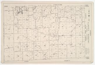
Detail maps of the southern section of District 60 of the 1940 tax assessment project. Map illustrates block numbers, appraised values, and plat boundaries, as well as streets and lakes. Map covers an area of southwestern Jackson County, from Hammond Road south to the Cass County line, and from Harris Road east to the Lafayette County line.

Detail maps of the south central section of District 60 of the 1940 tax assessment project. Map illustrates block numbers, appraised values, and plat boundaries, as well as streets and lakes. Map covers an area of southwestern Jackson County, from U.S. Highway 40 south to Hammond Road, and from west of Highway 7 east to the Lafayette County line.