Folder contains photographs of industrial buildings in an area of Northeast Kansas City between the Missouri River and the rail lines, 1st Street, and Front Street, and spanning from the Hannibal Bridge to the A.S.B. Bridge, which can be seen in the background of one of the images.
Search
Folder contains a photograph of a Kansas City Gas Company building in the East Kansas addition, from Front Street south to 1st Street, and Campbell Street east to Gillis Street. The A.S.B. Bridge can be seen in the background of the image. Folder also contains plat map of the block.
Detail maps of the north central section of District 60 of the 1940 tax assessment project. Map illustrates block numbers, appraised values, and plat boundaries, as well as streets, railroads, and rivers. Map covers an area of northeastern Jackson County, east to the Lafayette County line and north of Burgess and Doris Neeb Roads, and including the city of Buckner.
Detail map of the northern half of District 1 of the 1940 tax assessment project. Map illustrates block numbers, appraised values, and plat boundaries, as well as railroad lines and rivers. The map covers an area from the Missouri River south to what was later Front Street, and roughly from Jackson Avenue east to the Kansas City city limits.
Detail map of the northern section of District 2 of the 1940 tax assessment project. Map illustrates block numbers, appraised values, and plat boundaries, as well as railroad lines, streets, and rivers. The map covers an area from the Missouri River south to Rochester Avenue and east to Jackson Avenue.
Detail maps of the southern and western sections of District 2 of the 1940 tax assessment project. Maps illustrate block numbers, appraised values, and plat boundaries, as well as railroad lines, bridges, streets, and rivers. The southern map covers an area from the Missouri River and Rochester Avenue south to Independence Avenue, and Delaware Ave east to Troost Avenue; and the western map covers an area from the Missouri River south to 5th Street, and Broadway Boulevard east to Delaware Street.
Detail map of the southern industrial section of District 2 of the 1940 tax assessment project. Map illustrates block numbers, appraised values, and plat boundaries, as well as railroad lines, streets, bridges, and rivers. The map covers an area from the Missouri River south to 5th Street and Independence Avenue, and from Broadway Boulevard east to Troost Avenue.
Detail map of two industrial areas in District 3 of the 1940 tax assessment project. Map illustrates block numbers, appraised values, and plat boundaries, as well as railroad lines, streets, and rivers. The map on the left covers an area of the West Bottoms Industrial District from the Missouri River south to 14th Street and from the Kansas state line east to Beardsley Road, Bluff Drive, and Broadway Boulevard. The map on the right pictures blocks adjacent to Southwest Boulevard, from as far north as 21st Street and as far south as 31st Street.
Detail map of District 3 of the 1940 tax assessment project. Map illustrates block numbers, appraised values, and plat boundaries, as well as railroad lines, streets, and rivers. The map covers an area from the Missouri River south to 31st Street (west of Summit Street) and 25th Street (east of Summit Street), and from the Kansas state line east to Broadway Boulevard (north of 25th Street) and Summit Street (south of 25th Street).
Detail map of the northern section of District 30 of the 1940 tax assessment project. Map illustrates block numbers, appraised values, and plat boundaries, as well as streets and railroads. The map covers an area of north-central Jackson County, Missouri, south of the Missouri River and west of present day Highway 291.
Detail map of the northern half of District 7 of the 1940 tax assessment project. Map illustrates block numbers, appraised values, and plat boundaries, as well as railroad lines, streets, rivers, and other features. The map covers an area from Independence Avenue south to 31st Street, and from Topping Avenue east to Kansas City's 1940 eastern city limits.
Detail map of the southern half of District 7 of the 1940 tax assessment project. Map illustrates block numbers, appraised values, and plat boundaries, as well as railroad lines, streets, and rivers. The map covers an area from 31st Street south to 47th Street, and Topping Avenue east to Kansas City's 1940 eastern city limits.
Detail map of District 11 of the 1940 tax assessment project. Map illustrates block numbers, appraised values, and plat boundaries, as well as streets, railroads, and a Kansas City Public Service Company right of way. The map covers an area from 31st Street south to 47th Street, and the Kansas state line east to Troost Avenue.
Detail map of District 14 of the 1940 tax assessment project. Map illustrates block numbers, appraised values, and plat boundaries, as well as streets, railroads, and rivers. The map covers an area from 47th Street south to 63rd Street, and Prospect Avenue east to Kansas City's 1940 eastern city limits.
Detail map of District 15 of the 1940 tax assessment project. Map illustrates block numbers, appraised values, and plat boundaries, as well as streets, railroads, and other features. The map covers an area from 63rd Street south to 79th Street west of Agnes Avenue, and Kansas City's 1940 southern city limits east of Agnes Avenue.
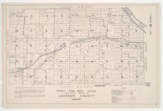
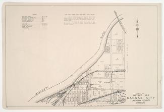
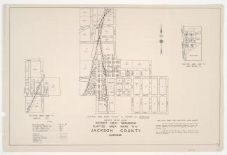
Small detail maps of platted areas I and L through Q of District 20 in Jackson County, Missouri. Maps illustrate block numbers, appraised values, and plat boundaries, as well as streets, waterways, and railroads. Map I covers the Holmes Park area from Bannister Road south to Gustin Road, and from roughly Oak Wood Drive east to Scott Road. Map L covers the Dallas area from 97th and 99th Streets south to roughly 105th Street, and from the blocks west of Jefferson Street east to the blocks east of Wornall Road. Map M covers a small area south of 103th Street/Voilland Road and east of Holmes Road. Map N covers the Hickman Mills area, from just north of Hickman Mills Road south to Hickman School Road, and from U.S. Highway 71 east to Ruskin Road. Map O covers an area adjacent to Lister Avenue at 114th Terrace. Map P covers an area from Red Bridge Road/Ridenour Road south to and inclusive of Glen Arbor Road, and from west of Glen Arbor Road east to Wornall Road. Map Q covers an area adjacent to the Kansas state line and Red Bridge Road, and west of Wornall Road.
Detail map of the northern section of District 20 of the 1940 tax assessment project. Map illustrates block numbers, appraised values, and plat boundaries, as well as streets, rivers, a coal mine, and other features. The map covers an area south and east of Kansas City's 1940 city limits.
Small detail maps of platted areas A through F and H of the northern half of District 20 in Jackson County, Missouri. Maps illustrate block numbers, appraised values, and plat boundaries, as well as streets and railroads. Map A covers an area from Topping Avenue east to Eastern Avenue, and 47th Street south roughly to 52nd Street. Map B covers an area east of Bennington Avenue, adjacent to U.S. Highway 50 and Harris Road/55th Street. Map C covers a small area around the intersection of Topping and 63rd Street. Map D covers an area from 63rd Street south to 65th Street, and Kansas City's 1940 city limits east to Bennington Avenue. Map E covers an area from Bennington Avenue east to Cambridge and Bristol Avenues, and 65th Street and Blue Ridge Boulevard south to 69th Street. Map F covers an area from 77th and 79th Streets south to 83rd and 86th Streets, and from Woodland Avenue east to Prospect Avenue and Indiana Avenue, and includes the location of Fairyland Park. Map H covers a small area from 83rd Street south to 84th Street, and Sunset Drive east to Oldham Road.
Detail map of the southern section of District 20 of the 1940 tax assessment project. Map illustrates block numbers, appraised values, and plat boundaries, as well as streets, rivers, and railroads. The map covers an area of Jackson County, Missouri, adjacent to the Kansas state line and the Cass County line.
Small detail maps of platted areas R through V and KK of the southern half of District 20 in Jackson County, Missouri. Maps illustrate block numbers, appraised values, and plat boundaries, as well as streets and railroads. Map R covers an area of Grandview adjacent to the intersection of Garner Avenue and Blue Ridge Boulevard, west of Grandview Road. Map S covers the New Santa Fe area from the Kansas state line east to Santa Fe Street, and from Prairie Street south to and inclusive of Market Street. Map T covers the Martin City area, from Birrell Road south to and inclusive of 135th Street, and from Broadway Boulevard east to Holmes Street and Charlotte Street. Map U covers an area from Axtell Road south to Sheldon Avenue and Forest Avenue, and from an area west of the Kansas City Southern rail lines east to East Avenue and Brighton Avenue. Map V covers an area of Grandview from north of Main Street south to 133rd Street and Forest Avenue, and from East Avenue and Brighton Avenue east to Topping Avenue and Parking Avenue.