Folder contains photographs of residences and other buildings in the Downtown East neighborhood, from 16th Street south to 17th Street, and Virginia Avenue east to Lydia Avenue, including a section of 16th Street Terrace.
Folder contains photographs of residences and other buildings in the Downtown East neighborhood, from 16th Street south to 17th Street, and Virginia Avenue east to Lydia Avenue, including a section of 16th Street Terrace.

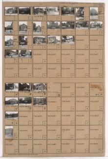
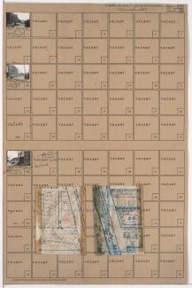
Folder contains photographs of residences in the West Blue Valley neighborhood, from 16th Terrace south to 17th Street, and Hardesty Avenue east to Oakley Avenue.

Folder contains photographs of residences and other buildings in the West Blue Valley neighborhood, from 15th Street (later Truman Road) south to 16th Street, and Denver Avenue east to Colorado Avenue.

Folder contains photographs of residences and other buildings in the West Blue Valley neighborhood, from 15th Street (later Truman Road) south to 16th Street, and Colorado Avenue east to Hardesty Avenue.

Folder contains photographs of residences in the West Blue Valley neighborhood, from 16th Street south to 16th Terrace, and Hardesty Avenue east to Oakley Avenue, including a section of Drury Avenue.

Folder contains photographs of residences in the West Blue Valley neighborhood, from 16th Street south to 16th Terrace, and Oakley Avenue east to Topping Avenue.
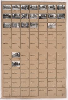
Folder contains photographs of residences and apartment buildings in the West Blue Valley neighborhood, from 16th Terrace south to 17th Street, and Oakley Avenue east to Topping Avenue.
Folder contains photographs of residences, businesses, and other buildings in the East Blue Valley neighborhood, from 15th Street (later Truman Road) south to 16th Terrace, and Bristol Avenue east to Corrington Avenue. Folder also contains a plat map of the block. A post office, at 15th and Corrington, is among the buildings pictured.
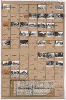
Folder contains photographs of residences and other buildings in the East Blue Valley neighborhood, from 15th Street (later Truman Road) south to 16th Terrace, and Winchester Avenue east to Bristol Avenue. Folder also contains plat map of the block, which can be viewed below.

Map of block in the East Blue Valley neighborhood, from 15th Street (later Truman Road) south to 16th Terrace, and Winchester Avenue east to Bristol Avenue, containing information about tax assessment values of included properties, and illustrating lot numbers for the block. Photographs of properties on the block can be viewed below.

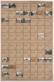
Folder contains photographs of residences in the East Blue Valley neighborhood, from 16th Street south to 16th Terrace, and Belmont Avenue east to Fremont Avenue.

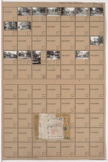
Folder contains photographs of residences in the East Blue Valley neighborhood, from 16th Street south to 16th Terrace, and Corrington Avenue east to Crystal Avenue. Folder also contains a plat map of the block.
Folder contains photographs of Security Stove Manufacturing Company buildings in the Blue Valley Industrial District, from 16th Terrace south to 17th Street, and Crystal Avenue east to Oakland Avenue. Folder also contains a plat map of the block.

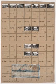
Folder contains photographs of residences in the East Blue Valley neighborhood, from 16th Terrace south to 17th Street, and Corrington Avenue east to Crystal Avenue. Folder also contains a plat map of the block.
Folder contains photographs of residences and apartment buildings in the East Blue Valley neighborhood, from 16th Terrace south to 17th Street, and Bristol Avenue east to Corrington Avenue. Folder also contains a plat map of the block.

Folder contains photographs of residences and other buildings in the East Blue Valley neighborhood, from 16th Terrace south to 17th Street, and Winchester Avenue east to Bristol Avenue. Folder also contains a plat map of the block.

Folder contains photographs of residences in the East Blue Valley neighborhood, from 16th Street south to 16th Terrace, and Bennington Avenue east to Ewing Avenue. Folder also contains a plat map of the block.

Folder contains photographs of residences in the East Blue Valley neighborhood, from 16th Street south to 16th Terrace, and Fremont Avenue east to Bennington Avenue.
Folder contains photographs of residences in the East Blue Valley neighborhood, from 16th Terrace south to 17th Street, and Fremont Avenue east to Bennington Avenue.

Folder contains photographs of residences in the East Blue Valley neighborhood, from 16th Terrace south to 17th Street, and Belmont Avenue east to Fremont Avenue. Folder also contains a plat map of the block.