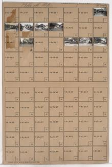
Tax Assessment Block Folder, Kansas City, MO, District 6, Block 174

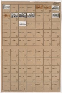
Folder contains photographs of residences in the Blue Valley neighborhood, from 20th Street south to 22nd Street, and Van Brunt Boulevard east to Hardesty Avenue.
Street Names
Folder contains photographs of residences in the Blue Valley neighborhood, from 20th Street south to 22nd Street, and Van Brunt Boulevard east to Hardesty Avenue.
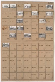
Folder contains photographs of residences in the Blue Valley neighborhood, from 20th Street south to 22nd Street, and Hardesty Avenue east to Drury Avenue.

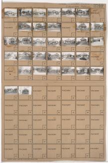
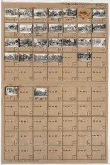
Folder contains photographs of residences in the Blue Valley neighborhood, from 22nd Street south to 23rd Street, and Van Brunt Boulevard east to Hardesty Avenue.

Folder contains photographs of residences in the Blue Valley neighborhood, from 22nd Street south to 23rd Street, and Hardesty Avenue east to Drury Avenue.

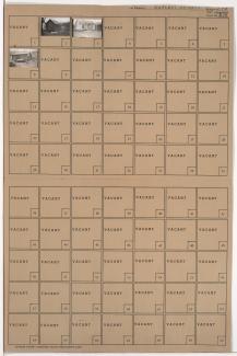
Folder contains photographs of residences in the Blue Valley neighborhood, from 22nd Street south to 23rd Street, and Drury Avenue east to Oakley Avenue.

Folder contains photographs of residences in the South Blue Valley neighborhood, from 30th Street south to 31st Street, and White Avenue east to Wheeling Avenue. Folder also includes a plat map of the block.

Folder contains photographs of residences in the South Blue Valley neighborhood, from 30th Street south to 31st Street, and Bellaire Avenue east to White Avenue. Folder also includes a plat map of the block.

Folder contains photographs of residences in the South Blue Valley neighborhood, from 30th Street south to 31st Street, and Wheeling Avenue east to Belmont Avenue. Folder also includes a plat map of the block.

Folder contains photographs of residences in the South Blue Valley neighborhood, from 30th Street south to 31st Street, and Topping Avenue east to Bellaire Avenue. Folder also includes a plat map of the block.

Folder contains photographs of residences in the South Blue Valley neighborhood, from 23rd Street south to 24th Street, and Oakley Avenue east to Lawndale Avenue.
Folder contains photographs of residences in the South Blue Valley neighborhood, from 23rd Street south to 24th Street, and Lawndale Avenue east to Topping Avenue.

Folder contains photographs of residences and businesses in the South Blue Valley neighborhood, from 23rd Street south to 24th Street, and Drury Avenue east to Oakley Avenue. Lakeview Market, at 5522 East 24th, is among the buildings pictured.
Folder contains photographs of residences and businesses in the South Blue Valley neighborhood, from 23rd Street south to 24th Street, and Hardesty Avenue east to Drury Avenue.
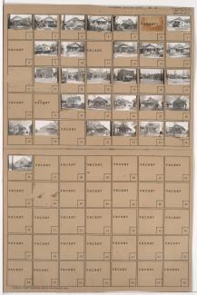
Folder contains photographs of residences and businesses in the South Blue Valley neighborhood, from 23rd Street south to 24th Street, and Van Brunt Boulevard east to Hardesty Avenue. Hiatt's B-B-Q, at 5304 East 24th, and 24th Street Hardware, at 5306 East 24th, are among the buildings pictured.
Folder contains photographs of residences, businesses, and other buildings in the South Blue Valley neighborhood, from 24th Street south to 25th Street, and Van Brunt Boulevard east to Hardesty Avenue. First Regular Baptist Church, at 2429 Van Brunt, is among the buildings pictured.
Folder contains photographs of residences and businesses in the South Blue Valley neighborhood, from 24th Street south to 25th Street, and Hardesty Avenue east to Drury Avenue. Parkview Pharmacy, at 2401 Hardesty, is among the buildings pictured.

Folder contains photographs of residences in the South Blue Valley neighborhood, from 24th Street south to 25th Street, and Drury Avenue east to Oakley Avenue.

Folder contains photographs of residences in the South Blue Valley neighborhood, from 24th Street south to 25th Street, and Oakley Avenue east to Lawndale Avenue.
Folder contains photographs of residences in the South Blue Valley neighborhood, from 24th Street south to 25th Street, and Lawndale Avenue east to Topping Avenue.

Folder contains photographs of residences in the South Blue Valley neighborhood, from 25th Street south to 26th Street, and Drury Avenue east to Oakley Avenue.