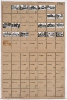
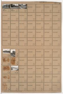
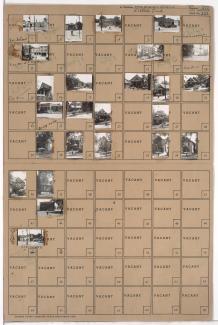
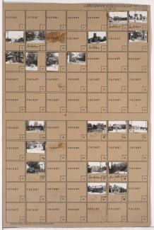
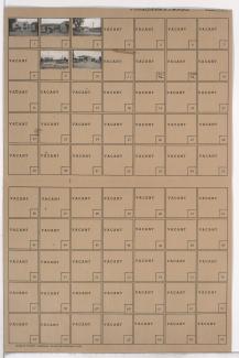
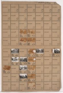
One of two folders containing photographs of residences, businesses, and other buildings in the Wendell Phillips neighborhood, from 19th Street south to 21st Street, and Vine Street east to Highland Avenue. Missouri Valley Oil Company, at 1927 Vine, is among the buildings pictured.
Search
Folder contains a photograph of a residence in the Washington Wheatley neighborhood, from 21st Street south to 22nd Street, and Bales Avenue east to Askew Avenue. A natural gas storage tank can be seen in the background of the image.
Folder contains photographs of residences and apartment buildings in the Washington Wheatley neighborhood, from 20th Street south to 21st Street, and Askew Avenue east to Monroe Avenue. A natural gas storage tank can be seen in the background of several images.
Folder contains photographs of buildings and industrial facilities in the Blue Valley Industrial District, from 12th Street south to 14th Street, and the railroad tracks east to Crystal Avenue.
Folder contains photographs of residences and apartment buildings in the East Community Team neighborhood, from 19th Street south to 20th Street, and Askew Avenue east to Monroe Avenue. A natural gas storage tank can be seen in the background of several images. Folder also includes a plat map of the block, which can be viewed below.
Folder contains photographs of residences and other buildings in the East Community Team neighborhood, from 19th Street south to 20th Street, and Indiana Avenue east to Askew Avenue. A Kansas City Gas Company building and natural gas storage tank, at 20th and Indiana, are among the buildings pictured.
Folder contains photographs of residences, businesses, and other buildings in the Volker neighborhood, from 31st Street south to 32nd Street, and Bell Street east to Roanoke Street. Tnemec Company, at 3122-3124 Roanoke, and Battenfeld Grease and Oil Company, at 3128-3130 Roanoke, are among the buildings pictured.
Folder contains photographs of residences and other buildings in the Westport neighborhood, from 40th Street south to Westport Road, and Waddell Avenue east to Mill Street. Kansas City Public Service Company building, at 40th and Waddell, and South Side Wood and Coal Company, at 536 Westport Road, are among the buildings pictured. Folder also includes a plat map of the block, which can be viewed below.
Folder contains photographs of businesses in the Tower Homes neighborhood south of the 1940 Kansas City city limits, from 77th Terrace south to 78th Street, and Wornall Road east to Brookside Boulevard.
First of three folders containing photographs of businesses and industrial buildings in the West Side neighborhood, from 25th Street south to the rail lines, and from the state line and Genessee Street southeast to Southwest Boulevard, including sections of 27th Street, Wyoming Street, 28th Street, and 28th Terrace. Skinmore Home Oil Company, at 2918 Southwest Boulevard, is among the buildings pictured.
Folder contains photographs of residences and other buildings in the West Side neighborhood, from 29th Street south to 30th Street, and Fairmount Avenue east to Terrace Street. Gate City Petroleum facilities, at 30th and Fairmount, are among the buildings pictured.
Folder contains photographs of businesses and other buildings in the West Side neighborhood, from Southwest Boulevard south to 31st Street, and Bell Street east to Roanoke Road.
Folder contains photographs of businesses and industrial buildings in the Hospital Hill neighborhood, from 19th Street south to 20th Street and the railroad lines, and Campbell Street east to Harrison Street. Eureka Petroleum Company facilities, at 19th and Harrison, are among the buildings pictured.
Folder contains photographs of businesses in the Hospital Hill neighborhood, from 20th Street and the rail lines south to 21st Street, and Campbell Street east to Harrison Street. City Ice facilities, at 21st and Harrison, are among the buildings pictured.
Folder contains photographs of businesses and other buildings in the Crossroads District, from 20th Street south to Milwaukee Avenue (22nd Street), and St. Paul Avenue east to Baltimore Avenue. The Liquid Carbonic Company building, at 2000 Baltimore, and Folger's Coffee buildings, at 2012 and 2024 Baltimore, are among the buildings pictured.