
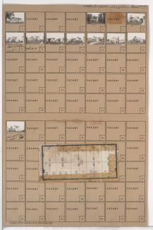
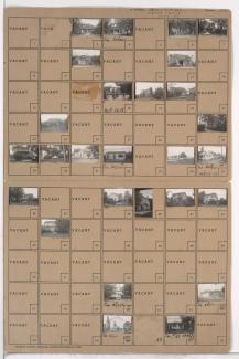
Folder contains photographs of residences in the Marlborough Pride neighborhood, from the 1940 Kansas City city limits south to 80th Street, and Michigan Avenue east to Euclid Avenue. Folder also includes a plat map of the block.
Folder contains photographs of residences in the Marlborough Pride neighborhood, from the 1940 Kansas City city limits south to 80th Street, and Michigan Avenue east to Euclid Avenue. Folder also includes a plat map of the block.

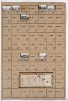
Folder contains photographs of residences in the Marlborough Pride neighborhood, from the 1940 Kansas City city limits south to 80th Street, and Euclid Avenue east to Garfield Avenue. Folder also includes a plat map of the block.

Folder contains photographs of residences in the Marlborough Pride neighborhood, from the 1940 Kansas City city limits south to 80th Street, and Garfield Avenue east to Brooklyn Avenue. Folder also includes a plat map of the block.

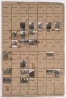
Folder contains photographs of residences in the Marlborough Pride neighborhood south of the 1940 Kansas City city limits, from 80th Street south to 81st Street, and Euclid Avenue east to Garfield Avenue. Folder also includes a plat map of the block.

Folder contains photographs of residences in the Marlborough Pride neighborhood south of the 1940 Kansas City city limits, from 80th Street south to 81st Street, and Garfield Avenue east to Brooklyn Avenue. Folder also includes a plat map of the block.

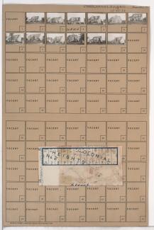
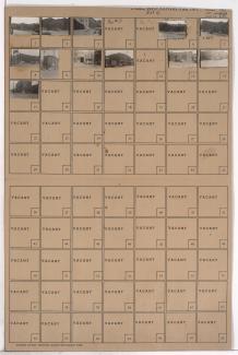
Folder contains photographs of residences in the West Waldo neighborhood south of the 1940 Kansas City city limits, from 80th Street south to 81st Street, and Madison Avenue east to Summit Street. Folder also includes a plat map of the block.
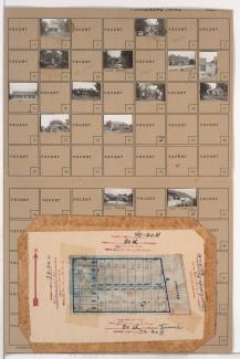
Folder contains photographs of residences in the West Waldo neighborhood south of the 1940 Kansas City city limits, from 79th Street south to 80th Street, and Holly Street east to Jarboe Street. Folder also includes a plat map of the block.
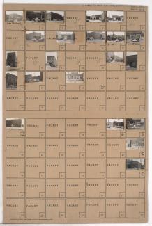
Folder contains photographs of residences and other buildings in the West Waldo neighborhood south of the 1940 Kansas City city limits, from 80th Street south to 81st Street, and Holly Street east to Jarboe Street. Folder also includes a plat map of the block.

Folder contains photographs of residences in the West Waldo neighborhood south of the 1940 Kansas City city limits, from 80th Street south to 81st Street, and Jarboe Street east to Belleview Avenue. Folder also includes a plat map of the block.

Folder contains photographs of residences in the West Waldo neighborhood south of the 1940 Kansas City city limits, from 79th Street south to 80th Street, and Belleview Avenue east to Madison Avenue. Folder also includes a plat map of the block.

Folder contains photographs of residences in the West Waldo neighborhood south of the 1940 Kansas City city limits, from 80th Street south to 81st Street, and Belleview Avenue east to Madison Avenue. Folder also includes a plat map of the block.
Folder contains photographs of residences in the West Waldo neighborhood south of the 1940 Kansas City city limits, from 79th Street south to 80th Street, and Madison Avenue east to Summit Street. Folder also includes a plat map of the block.
Folder contains photographs of residences and businesses in the Waldo Homes neighborhood south of the 1940 Kansas City city limits, from 80th Street south to 80th Terrace, and Wornall Road east to Brookside Boulevard. Folder also includes a plat map of the block.
Folder contains photographs of residences, businesses, and other buildings in the Rockhill Manor neighborhood south of the 1940 Kansas City city limits, from 79th Street south to 81st Street, and Holmes Street east to Troost Avenue, including sections of 80th Street and 80th Terrace.

Folder contains photographs of residences in the Marlborough Heights neighborhood south of the 1940 Kansas City city limits, from 80th Street south to 80th Terrace, and Forest Avenue east to Tracy Avenue. Folder also includes a plat map of the block.

Folder contains photographs of buildings in the West Bottoms district, from Market Street south to Woodswether Road, and State Avenue east to Hickory Street.
Folder contains photographs of industrial buildings in the West Bottoms district, from the Intercity Trafficway south to 8th Street and 9th Street, and the state line east to Hickory Street and Mulberry Street, bisected by Wyoming Street and Liberty Street. The Sewall Paint and Varnish Company is among the buildings pictured.
Folder contains photographs of businesses and other buildings in the West Bottoms district, from 8th Street south to 9th Street, and Hickory Street east to Mulberry Street. Pure Carbonic Incorporated and Stone's Body Shop are among the buildings pictured.
Folder contains photographs of businesses and other buildings in the West Bottoms district, from 9th Street south to St. Louis Avenue, and Hickory Street east to Mulberry Street. Gifford's Cafe, at 1314 St. Louis, is among the buildings pictured. The building that was once home to Jim Pendergast's Climax Saloon, at 1320 St. Louis, is among the buildings pictured.

Folder contains photographs of businesses and other buildings in the West Bottoms district, from 9th Street south to St. Louis Avenue, and Liberty Street east to Hickory Street. Central Storage Company, 1423 West 9th, and Unxld Fireworks, at 1413 West 9th, are among the buildings pictured.