
Folder contains a photograph of a residence in the Blue Valley Park neighborhood, in an area adjacent to the intersection of Bennington Avenue and US Highway 40.
Folder contains a photograph of a residence in the Blue Valley Park neighborhood, in an area adjacent to the intersection of Bennington Avenue and US Highway 40.

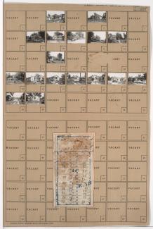
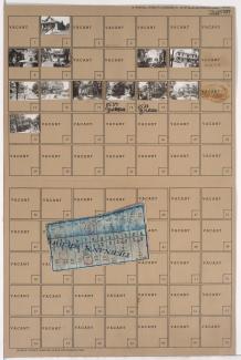
Folder contains photographs of residences in the Leeds neighborhood, from 31st Street south to 32nd Street, and White Avenue east to Wheeling Avenue, including a section of US Highway 40. Folder also includes a plat map of the block.
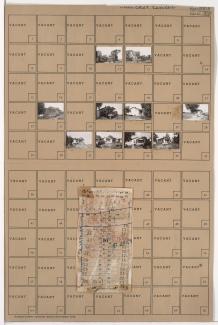
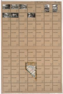
Folder contains photographs of residences and other buildings in the Leeds neighborhood, from 31st Street south to 32nd Street, and Topping Avenue east to Bellaire Avenue, including a section of US Highway 40. Folder also includes a plat map of the block.
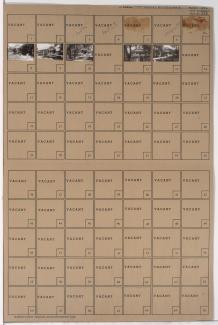
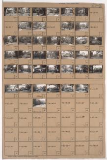
Folder contains photographs of residences and other buildings in the Leeds neighborhood, from 31st Street south to 32nd Street, and Bellaire Avenue east to White Avenue, including a section of US Highway 40. Folder also includes a plat map of the block.

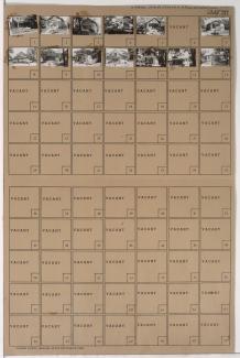
Folder contains photographs of residences and other buildings in the Volker neighborhood, from roughly 35th Terrace/Karnes Boulevard and Park Court south to Roanoke Parkway, and Karnes Boulevard east to Wyoming Street. Folder also includes a plat map of the block.

Folder contains photographs of residences, apartments, and other buildings in the Volker neighborhood, from 37th Street south to Valentine Road, and Wyoming Street and West Roanoke Drive east to East Roanoke Drive. Volker School, at 3715 Wyoming, is among the buildings pictured. Folder also includes a plat map of the block.
Folder contains photographs of residences in the Volker neighborhood, from 35th Street south to 35th Terrace, and Wyoming Street east to Terrace Street.

Folder contains photographs of apartment buildings in the Volker neighborhood, from Roanoke Parkway south to 37th Street and Wyoming Street east to West Roanoke Parkway. Folder also includes a plat map of the block.
Folder contains photographs of residences in the Volker neighborhood, from 35th Street south to 35th Terrace, and Genessee Street east to Wyoming Street.
Folder contains photographs of residences and apartment buildings in the Volker neighborhood, from 35th Terrace south to 36th Street, and Genessee Street east to Wyoming Street. Folder also includes a plat map of the block.

Folder contains photographs of residences and apartment buildings in the Volker neighborhood, from 36th Street south to 37th Street, and Genessee Street east to Wyoming Street. Folder also includes a plat map of the block.

Folder contains photographs of residences and apartment buildings in the Volker neighborhood, from 37th Street south to Valentine Road, and Genessee Street east to Wyoming Street. Folder also includes a plat map of the block.

Folder contains photographs of residences and businesses in the Volker neighborhood, from Valentine Road south to 39th Street, and Genessee Street east to Wyoming Street. Buck's Auto Repair, at 1610 West 39th, is among the buildings pictured. Folder also includes a plat map of the block.

Folder contains photographs of residences, businesses, and apartment buildings in the Volker neighborhood, from Valentine Road south to 39th Street, and Wyoming Street east to Terrace Street. Roanoke Sheet Metal Works, at 1410 West 39th, is among the buildings pictured. Folder also includes a plat map of the block.
Folder contains photographs of residences in the Westwood neighborhood, from 48th Street south to Westwood Road, and Wyoming Street east to Fairmount Avenue.

Folder contains photographs of residences in the West Plaza neighborhood, from 47th Street south to 48th Street, and Wyoming Street east to Fairmount Avenue.

Folder contains photographs of residences in the Westwood neighborhood, from 47th Street south to 49th Street, and State Line Road east to Wyoming Street, including a section of Bell Street. Folder also includes a plat map of the block.

Folder contains photographs of residences in the Westwood neighborhood, from Westwood Terrace west to Wyoming Street and south to 50th Street. Folder also includes a plat map of the block.
Folder contains photographs of residences in the Westwood neighborhood, from Westwood Road southwest to Westwood Terrace, and Wyoming Street southeast to 50th Street.

Folder contains photographs of residences in the Westwood neighborhood, from 49th Street south to 50th Street, and Bell Street east to Wyoming Street. Folder also includes a plat map of the block.