
Folder contains photographs of residences in the Sunset Hill neighborhood, from 53rd Street south to 53rd Terrace, and Belleview Avenue east to Summit Street.
Folder contains photographs of residences in the Sunset Hill neighborhood, from 53rd Street south to 53rd Terrace, and Belleview Avenue east to Summit Street.

Folder contains photographs of residences in the Sunset Hill neighborhood, from 53rd Terrace south to 54th Street, and Belleview Avenue east to Summit Street.
Folder contains photographs for residences in the Countryside neighborhood, from 53rd Street south to 53rd Terrace, and Broadway Boulevard east to Wyandotte Street.

Folder contains photographs of residences in the Countryside neighborhood, from 53rd Terrace south to 54th Street, and Wornall Road east to Wyandotte Street.

Folder contains photographs of residences in the Countryside neighborhood, from 53rd Street south to 53rd Terrace, and Wyandotte Street east to Main Street.

Folder contains photographs of residences in the Countryside neighborhood, from 53rd Terrace south to 54th Street, and Wyandotte Street east to Main Street.
Folder contains photographs of residences in the Countryside neighborhood, from 53rd Terrace south to 54th Street, and Main Street east to Brookside Boulevard.
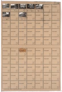
Folder contains photographs of residences in the Swope Parkway neighborhood, from 53rd Street south to 53rd Terrace, and Jackson Avenue east to Kensington Avenue. Folder also includes a plat map of the block.

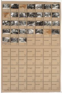
Folder contains photographs of residences in the Swope Parkway neighborhood, from 53rd Terrace south to 54th Street, and Jackson Avenue east to Kensington Avenue.

Folder contains photographs of residences in the Swope Parkway neighborhood, from 53rd Street south to 53rd Terrace, and Cleveland Avenue east to Myrtle Avenue.

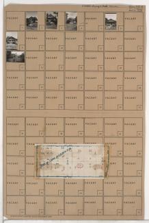
Folder contains photographs of residences in the Swope Parkway neighborhood, from 53rd Terrace south to 54th Street, and Kensington Avenue east to Elmwood Avenue. Folder also includes a plat map of the block.
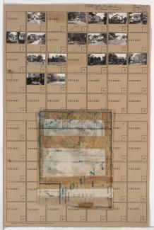
Folder contains photographs of residences in the Swope Parkway neighborhood, from 53rd Terrace south to 55th Street, and Cleveland Avenue east to Myrtle Avenue. Folder also includes a plat map of the block.

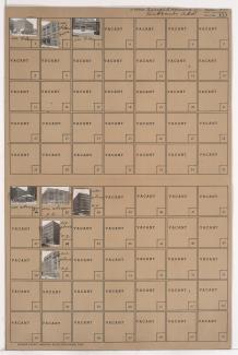
Folder contains photographs of businesses and other buildings in downtown Kansas City, from 5th Street south to 6th Street Trafficway, and May Street east to Central Street. Standard Paper & Woodenware Company, at 304 West 6th, is among the buildings pictured.

Folder contains photographs of businesses and other buildings in downtown Kansas City, from 5th Street south to 6th Street Trafficway, and Broadway Boulevard east to May Street. Graham Paper Company, at 332-336 West 6th, is among the buildings pictured.
Folder contains photographs of businesses and other buildings in downtown Kansas City, from 6th Street Trafficway south to 7th Street, and May Street east to Central Street. Enterprise Furniture & Stove Company, at 600 Central, and McPike Drug Company, at 7th and Central, are among the buildings pictured.
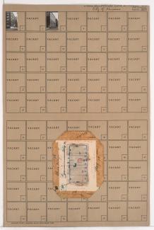
Folder contains photographs of buildings in downtown Kansas City, from 7th Street south to 8th Street, and Broadway Boulevard east to May Street. The Folgers Coffee Company, at 8th and Broadway, is among the buildings pictured. Folder also includes plat map of the block.
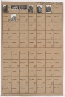
Folder contains photographs of businesses and other buildings in downtown Kansas City, from 7th Street south to 8th Street, and May Street east to Central Street. The Tom B. Owens Building, at 7th and Central, and the Burd and Fletcher Printing Company, at 7th and May St, are among the buildings pictured.

Folder contains photographs of businesses and other buildings in downtown Kansas City, from 8th Street south to 9th Street, and May Street east to Central Street. The U.S. Rubber Company, at 8th and May, Lewis Printing Company, at 307-311 West 8th, and the Harry J. Epstein Company, at 301 West 8th Street, are among the buildings pictured.