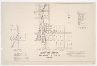
Small detail maps of platted areas R through V and KK of the southern half of District 20 in Jackson County, Missouri. Maps illustrate block numbers, appraised values, and plat boundaries, as well as streets and railroads. Map R covers an area of Grandview adjacent to the intersection of Garner Avenue and Blue Ridge Boulevard, west of Grandview Road. Map S covers the New Santa Fe area from the Kansas state line east to Santa Fe Street, and from Prairie Street south to and inclusive of Market Street. Map T covers the Martin City area, from Birrell Road south to and inclusive of 135th Street, and from Broadway Boulevard east to Holmes Street and Charlotte Street. Map U covers an area from Axtell Road south to Sheldon Avenue and Forest Avenue, and from an area west of the Kansas City Southern rail lines east to East Avenue and Brighton Avenue. Map V covers an area of Grandview from north of Main Street south to 133rd Street and Forest Avenue, and from East Avenue and Brighton Avenue east to Topping Avenue and Parking Avenue.