Folder contains photographs of a residence and a school in the Tri-Blenheim neighborhood, from 70th Terrace south to Gregory Boulevard, and Olive Street east to Prospect Avenue. Blenheim School, at Olive and Gregory, is among the buildings pictured.
Folder contains photographs of a residence and a school in the Tri-Blenheim neighborhood, from 70th Terrace south to Gregory Boulevard, and Olive Street east to Prospect Avenue. Blenheim School, at Olive and Gregory, is among the buildings pictured.
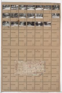
Folder contains photographs of residences and businesses in the Holmes Park neighborhood, from 70th Terrace south to Gregory Boulevard, and Oak Street east to Cherry Street. Folder also includes a plat map of the block.

Folder contains photographs of residences in the Armour Hills neighborhood, from Dartmouth Road south to 70th Terrace, and Rockhill Road east to Oak Street.
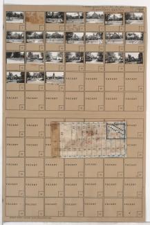
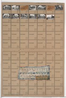
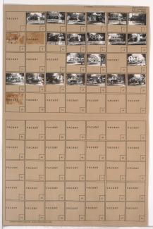
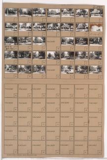
Folder contains photographs of residences, businesses, and other buildings in the Holmes Park neighborhood, from 70th Street south to Gregory Road, and Holmes Road east to Troost Avenue, including a section of 70th Terrace. Folder also includes a plat map of the block, which can be viewed below.

Map of block in the Holmes Park neighborhood, from 70th Street south to Gregory Road, and Holmes Road east to Troost Avenue, including a section of 70th Terrace, containing information about tax assessment values of included properties, and illustrating lot numbers for the block. Photographs of properties on the block can be viewed below.

Folder contains photographs of residences in the Holmes Park neighborhood, from 70th Street south to 70th Terrace, and Cherry Street east to Holmes Road. Folder also includes a plat map of the block.
Folder contains photographs of residences in the Holmes Park neighborhood, from 70th Terrace south to Gregory Boulevard, and Cherry Avenue east to Holmes Road. Folder also includes a plat map of the block.

Folder contains photographs of residences in the Holmes Park neighborhood, from 70th Street south to 70th Terrace, and Oak Street east to Cherry Street. Folder also includes a plat map of the block.
Folder contains photographs of residences and businesses in the Armour Hills neighborhood, from 70th Terrace south to Gregory Boulevard, and Rockhill Road east to Oak Street. Folder also includes a plat map of the block.

Folder contains photographs of residences in the Armour Hills neighborhood, from Dartmouth Road south to 70th Terrace, and Main Street east to Rockhill Road. Folder also includes a plat map of the block.

Folder contains photographs of residences in the Armour Hills neighborhood, from Dartmouth Road and 70th Street south to 70th Terrace, and Brookside Road east to Main Street. Folder also includes a plat map of the block.

Folder contains photographs of residences in the Armour Hills neighborhood, from 70th Terrace south to Gregory Boulevard, and Brookside Road east to Main Street. Folder also includes a plat map of the block.

Folder contains photographs of residences in the Armour Fields neighborhood, from 70th Street south to 70th Terrace, and Ward Parkway east to Valley Road.

Folder contains photographs of residences in the Armour Fields neighborhood, from 70th Street and Dartmouth Road south to 70th Terrace, and Valley Road east to Jefferson Street.
Folder contains photographs of residences in the Armour Fields neighborhood, from Dartmouth Road south to 70th Terrace, and Jefferson Street (later Edgevale Road) east to Wornall Road.

Folder contains photographs of residences and businesses in the Armour Fields neighborhood, from 70th Terrace south to Gregory Boulevard, and Jefferson Street (later Edgevale Road) east to Wornall Road.

Folder contains photographs of residences in the Armour Fields neighborhood, from 70th Terrace south to Gregory Boulevard, and Ward Parkway east to Valley Road.
Folder contains photographs of residences in the Armour Fields neighborhood, from 70th Terrace south to Gregory Boulevard, and Valley Road east to Jefferson Street (later Edgevale Road).

Folder contains photographs of residences in the Romanelli West neighborhood, from 67th Street south to Gregory Boulevard, and State Line Road east to Ward Parkway, including sections of Arno Road, 69th Terrace, Romany Road, 70th Street, and 70th Terrace.

Folder contains photographs of residences in the Matthews & Hills addition, from Winner Road south to Thompson Avenue, and Manchester Avenue east to Smalley Avenue. Folder also includes plat map of the block.