Folder contains photographs of residences in the Hillcrest neighborhood, south of the 1940 Kansas City city limits and east of Hillcrest Road.
Street Names
Folder contains photographs of residences in the Hillcrest neighborhood, south of the 1940 Kansas City city limits and east of Hillcrest Road.
Folder contains a photograph of a residence in the Hillcrest neighborhood, south of the 1940 Kansas City city limits and north of 83rd Street, and east of Hillcrest Road.
Folder contains photographs of residences and farm buildings in the Hillcrest neighborhood, from the 1940 Kansas City city limits south to 83rd Street, and from Goodman Road east to Hillcrest Road.
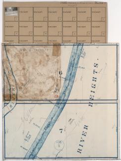
Folder contains photographs of residences in the Hillcrest neighborhood, south of the 1940 Kansas City city limits, and from the Blue River east to Blue River Road. Folder also includes a plat map of the area, which can be viewed below.
Folder contains a photograph of a residence in the Hillcrest neighborhood, south of the 1940 Kansas City city limits and east of Blue River Road. Folder also includes a plat map of the area.
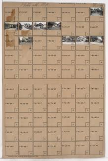
Map of block in the Hillcrest neighborhood, south of the 1940 Kansas City city limits, and from the Blue River east to Blue River Road, containing information about tax assessment values of included properties, and illustrating lot numbers for the block. Photographs of properties on the block can be viewed below.
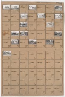
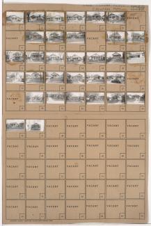
Folder contains photographs of residences in the Hillcrest neighborhood south of the 1940 Kansas City city limits, north of 83rd Street and east of Blue River Road. Folder also includes a plat map of the block.
Folder contains photographs of residences in the Blue Valley neighborhood, from 20th Street south to 22nd Street, and Van Brunt Boulevard east to Hardesty Avenue.
Folder contains photographs of residences in the Blue Valley neighborhood, from 20th Street south to 22nd Street, and Hardesty Avenue east to Drury Avenue.
Folder contains photographs of residences in the Blue Valley neighborhood, from 22nd Street south to 23rd Street, and Van Brunt Boulevard east to Hardesty Avenue.
Folder contains photographs of residences in the Blue Valley neighborhood, from 22nd Street south to 23rd Street, and Hardesty Avenue east to Drury Avenue.
Folder contains photographs of residences in the Blue Valley neighborhood, from 22nd Street south to 23rd Street, and Drury Avenue east to Oakley Avenue.
Folder contains photographs of residences in the South Blue Valley neighborhood, from 30th Street south to 31st Street, and White Avenue east to Wheeling Avenue. Folder also includes a plat map of the block.
Folder contains photographs of residences in the South Blue Valley neighborhood, from 30th Street south to 31st Street, and Bellaire Avenue east to White Avenue. Folder also includes a plat map of the block.
Folder contains photographs of residences in the South Blue Valley neighborhood, from 30th Street south to 31st Street, and Wheeling Avenue east to Belmont Avenue. Folder also includes a plat map of the block.
Folder contains photographs of residences in the South Blue Valley neighborhood, from 30th Street south to 31st Street, and Topping Avenue east to Bellaire Avenue. Folder also includes a plat map of the block.
Folder contains photographs of residences in the South Blue Valley neighborhood, from 23rd Street south to 24th Street, and Oakley Avenue east to Lawndale Avenue.
Folder contains photographs of residences in the South Blue Valley neighborhood, from 23rd Street south to 24th Street, and Lawndale Avenue east to Topping Avenue.
Folder contains photographs of residences and businesses in the South Blue Valley neighborhood, from 23rd Street south to 24th Street, and Drury Avenue east to Oakley Avenue. Lakeview Market, at 5522 East 24th, is among the buildings pictured.
Folder contains photographs of residences and businesses in the South Blue Valley neighborhood, from 23rd Street south to 24th Street, and Hardesty Avenue east to Drury Avenue.