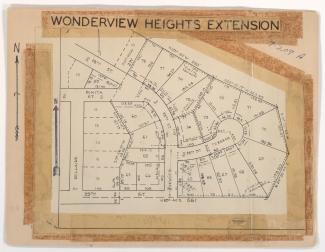
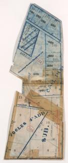
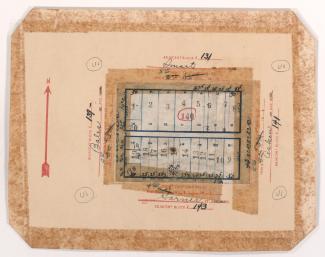
Map of block in the East Blue Valley neighborhood, from 15th Street (later Truman Road) south to 16th Terrace, and Winchester Avenue east to Bristol Avenue, containing information about tax assessment values of included properties, and illustrating lot numbers for the block. Photographs of properties on the block can be viewed below.
Search
Map of block in the East Blue Valley neighborhood, from 15th Street (later Truman Road) south to 17th Street, and Ewing Avenue east to Winchester Avenue, containing information about tax assessment values of included properties, and illustrating lot numbers for the block. Photographs of properties on the block can be viewed below.
Map of block in the Blue Valley neighborhood, from 17th and 18th Streets south to the Blue River and 19th Street, and from the railroad tracks east to Eastern and Winchester Avenues, including a section of Bristol Avenue, containing information about tax assessment values of included properties, and illustrating lot numbers for the block. Photographs of properties on the block can be viewed below.
Map of block in the Blue Valley Park neighborhood, south of 23rd Street and east of Belmont Avenue, including a section of Beacon Avenue, containing information about tax assessment values of included properties, and illustrating lot numbers for the block. Photographs of properties on the block can be viewed below.
Map of block in the Blue Valley Park neighborhood, from US Highway 40 and the Westport Independence Road south to 30th and 31st Streets, and east of Topping Avenue, containing information about tax assessment values of included properties, and illustrating lot numbers for the block. Photographs of properties on the block can be viewed below.
Map of block in the Knoches Park neighborhood, from 29th Street south to 31st Street, and Jackson Avenue east to Spruce Avenue, containing information about tax assessment values of included properties, and illustrates lot numbers for the block. Photographs of properties on the block can be viewed below.
Map of block in the Santa Fe neighborhood, from 27th Street south to Lockridge Street, and Prospect Avenue east to Benton Boulevard, containing information about tax assessment values of included properties, and illustrating lot numbers for the block. Photographs of properties on the block can be viewed below.
Map of block in the Vineyard Northwest neighborhood, from 41st Street south to 43rd Street, and Jackson Avenue east to Spruce Avenue, containing information about tax assessment values of included properties, and illustrating lot numbers for the block. Photographs of properties on the block can be viewed below.
Map of block in the Palestine West neighborhood, from Linwood Boulevard south to 33rd Street, and Indiana Avenue east to Cleveland Avenue, containing information about tax assessment values of included properties, and illustrates lot numbers for the block. Photographs of properties on the block can be viewed below.
Map of block in the Westport neighborhood, from 40th Street south to Westport Road, and Waddell Avenue east to Mill Street, containing information about tax assessment values of included properties, and illustrating lot numbers for the block. Photographs of properties on the block can be viewed below.
Map of block in the Oak Park Southeast neighborhood, from 41st Street south to 43rd Street, and College Avenue east to Indiana Avenue, containing information about tax assessment values of included properties, and illustrating lot numbers for the block. Photographs of properties on the block can be viewed below.
Map of block in the Oak Park Southeast neighborhood, from 41st Street south to 43rd Street, and Benton Boulevard east to College Avenue, containing information about tax assessment values of included properties, and illustrating lot numbers for the block. Photographs of properties on the block can be viewed below.
Map of block in the Oak Park Southeast neighborhood, from Benton Boulevard north to 45th Street and east to Indiana Avenue, containing information about tax assessment values of included properties, and illustrating lot numbers for the block. Photographs of properties on the block can be viewed below.
Map of block in the Old Hyde Park neighborhood, from 31st Street south to Linwood Boulevard, and Main Street east to McGee Street, including sections of 31st Terrace and Grand Avenue, containing information about tax assessment values of included properties, and illustrating lot numbers for the block. Photographs of properties on the block can be viewed below.
Map of an area in the Volker neighborhood, from 36th Street south to 37th Street, and State Line Road east to Bell Street illustrating lot numbers for the block.
Map of block in the Scarritt Point neighborhood, from Smart Avenue south to Garner Avenue, and Bales Avenue east to Indiana Avenue, containing information about tax assessment values of included properties, and illustrating lot numbers for the block. Photographs of properties on the block can be viewed below.
Map of block in the Oak Park Southeast neighborhood, from 41st Street south to 43rd Street, and College Avenue east to Indiana Avenue, containing information about tax assessment values of included properties, and illustrating lot numbers for the block. Photographs of properties on the block can be viewed below.
Map of block in the Blue Hills neighborhood, from 60th Street south to 62nd Street, and Park Avenue east to Prospect Avenue, including sections of Wabash Avenue and Olive Street, containing information about tax assessment values of included properties, and illustrating lot numbers for the block. Photographs of properties on the block can be viewed below.
Plat map of an area of the Citadel neighborhood, northwest of 62nd Street and Park Avenue along Brooklyn Avenue, containing information about tax assessment values of included properties, and illustrating lot numbers for the block.
Map of block in the the Volker neighborhood, from 41st Street south to Westport Road, and Roanoke Road east to Clark Avenue, containing information about tax assessment values of included properties, and illustrating lot numbers for the block. Photographs of properties on the block can be viewed below.