Tax Assessment Block Folder, Kansas City, MO, District 11, Block 237

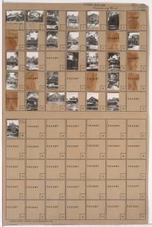
Folder contains photographs of residences in the Southmoreland neighborhood, from 40th Street south to 41st Street, and McGee Street east to Oak Street.
Street Names
Folder contains photographs of residences in the Southmoreland neighborhood, from 40th Street south to 41st Street, and McGee Street east to Oak Street.

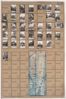
Folder contains photographs of residences, apartments, and other buildings in the Southmoreland neighborhood, from 39th Street south to 40th Street, and McGee Street east to Oak Street. Westport High School, at 315 East 39th, is among the buildings pictured. Folder also includes a plat map of the block.
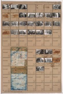
Folder contains photographs of residences, businesses, and apartment buildings in the Southmoreland neighborhood, from 39th Street south to 40th Street, and Warwick Boulevard east to McGee Street.
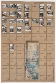
Folder contains photographs of residences, businesses, and other buildings in the Southmoreland neighborhood, from 39th Street south to 40th Street, and Walnut Street east to Warwick Boulevard. The Third Church of Christ, Scientist (later Midtown Baptist Temple), at 3953 Walnut, a Southwestern Bell Telephone Company building, at 39th and Main, and the Westport Manor Apartments, at 110-112 East 40th, are among the buildings pictured. Folder also includes a plat map of the block.

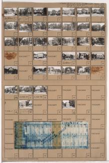
Folder contains photographs of residences and apartment buildings in the Southmoreland neighborhood, from 40th Street south to 41st Street, and Main Street east to Walnut Street. St. Paul's Episcopal Church, at 40th and Main, and Rollins School, at 4043 Main, are among the buildings pictured. Folder also includes a plat map of the block.
Folder contains photographs of apartment buildings in the Southmoreland neighborhood, from 40th Street south to 41st Street, and Walnut Street east to Warwick Boulevard.
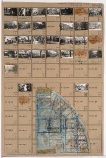
Folder contains photographs of residences, businesses, and apartment buildings in the Southmoreland neighborhood, from 39th Street south to 40th Street, and Main Street east to Walnut Street. Milgram's Grocery Store, at 3961 Main, the Montrose Apartment Hotel, at 40th and Walnut, and the Warwick Theater, at 3927 Main, are among the buildings pictured. Folder also includes a plat map of the block.

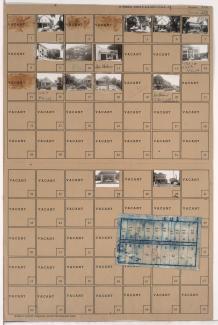
Folder contains photographs of residences and apartment buildings in the Southmoreland neighborhood, from 40th Street south to 41st Street, and Warwick Boulevard south to McGee Street.

Folder contains photographs of residences and businesses in the Southmoreland neighborhood, from 41st Street south to 43rd Street, and McGee Street east to Oak Street. Folder also includes a plat map of the block.

Folder contains photographs of residences and apartment buildings in the Southmoreland neighborhood, from 41st Street south to 42nd Street, and Locust Street east to Gillham Road. The Bon Air Apartments, at 4133 Locust, is among the buildings pictured. Folder also includes a plat map of the block.

Folder contains photographs of residences and apartment buildings in the Southmoreland neighborhood, from 41st Street south to 43rd Street, and Warwick Boulevard east to McGee Street. The Berkeley Apartments, at 200-206 East 43rd, are among the buildings pictured. Folder also includes a plat map of the block.

Folder contains photographs of residences and apartment buildings in the Southmoreland neighborhood, from 41st Street south to 43rd Street, and Walnut Street east to Warwick Boulevard. Folder also includes a plat map of the block.
Folder contains photographs of residences, businesses, and other buildings in the Southmoreland neighborhood, from 41st Street south to 43rd Street, and Main Street east to Walnut Street. Folder also includes a plat map of the block.

Folder contains photographs of residences and apartment buildings in the Southmoreland neighborhood, from 43rd Street south to 44th Street, and McGee Street east to Oak Street. The Roland Bruner House (also known as Mineral Hall), at 4340 Oak, is among the buildings pictured. Folder also includes a plat map of the block.
Folder contains photographs of residences and apartment buildings in the Southmoreland neighborhood, from 43rd Street south to 44th Street, and Oak Street east to Rockhill Road, including a section of Locust Street. The Donaldson House, at 4347 Oak, is among the buildings pictured. Folder also includes a plat map of the block.

Folder contains photographs of residences in the Southmoreland neighborhood, from 43rd Street south to 44th Street, and Warwick Boulevard east to McGee Street. Folder also includes a plat map of the block.

Folder contains photographs of residences in the Southmoreland neighborhood, from 43rd Street south to 44th Street, and Walnut Street east to Warwick Boulevard.
Folder contains photographs of residences, businesses, and other buildings in the Southmoreland neighborhood, from 43rd Street south to 44th Street, and Main Street east to Walnut Street. The Karnopp Building, at 43rd and Main, is among the buildings pictured. Folder also includes a plat map of the block.

Folder contains photographs of residences and other buildings in the Southmoreland neighborhood, from 44th Street south to 45th Street, and Main Street east to Warwick Boulevard, including a section of Walnut Street. Kansas City Art Institute buildings, on Warwick, are among the buildings pictured. Folder also includes a plat map of the block.

Folder contains photographs of residences in the Southmoreland neighborhood, from 44th Street south to 45th Street, and Oak Street east to Rockhill Road. Folder also includes a plat map of the block.