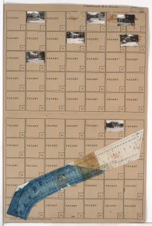
Folder contains a photograph of a residence in the Swope Parkway neighborhood, from 58th Street south to 59th Street, and Denver Avenue east to Colorado Avenue. Folder also includes a plat map of the block.
Folder contains a photograph of a residence in the Swope Parkway neighborhood, from 58th Street south to 59th Street, and Colorado Avenue east to Hardesty Avenue. Folder also includes a plat map of the block.
Folder contains photographs of residences in the Swope Parkway neighborhood, from 57th Terrace south to 58th Street, and Denver Avenue east to Colorado Avenue. Folder also includes a plat map of the block.
Folder contains photographs of residences and other buildings in the Eastwood Hills West neighborhood, from 49th Street south to Blue Ridge Road, and the Blue River east to Colorado Avenue. Folder also includes a plat map of the block.
Folder contains photographs of residences and other buildings in the Eastwood Hills West neighborhood, from 49th Street south to Blue Ridge Road, and Colorado Avenue east to Hardesty Avenue. Folder also includes a plat map of the block.
Folder contains photographs of residences in the Eastwood Hills West neighborhood, from Blue Banks Road south to the Blue River, and Brighton Avenue east to Colorado Avenue. Hackett's Market, at Blue Banks and Brighton, is among the buildings pictured. Folder also includes a plat map of the block.
Folder contains photographs of residences in the Eastwood Hills West neighborhood, from 47th Street south to Blue Banks Avenue, and Brighton Avenue east to the Blue River, including sections of Quincy, Denver, Colorado, and Hardesty Avenues.
Folder contains photographs of residences and other businesses in the Eastwood Hills West neighborhood, from the Blue River east to Brighton Avenue and north to Blue Banks Avenue, including a section of Colorado Avenue.
Folder contains a photograph of a residence in the Dunbar neighborhood, from 33rd Street south to 34th Street, and Denver Avenue east to Colorado Avenue. Folder also includes a plat map of the block.
Folder contains photographs of residences and businesses in the Knoches Park neighborhood, from 29th Street south to Linwood Boulevard, and Colorado Avenue east to Van Brunt Boulevard. Folder also includes a plat map of the block.