Greenway Terrace

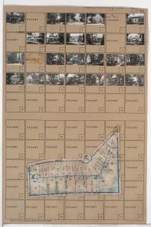
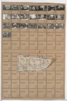
Tax Assessment Block Map, Kansas City, MO, District 17, Block 108

Map of block in the Country Club District, from Greenway Terrace south to Meyer Boulevard, and Ward Parkway east to Valley Road, containing information about tax assessment values of included properties, and illustrating lot numbers for the block. Photographs of properties on the block can be viewed below.

Tax Assessment Block Folder, Kansas City, MO, District 17, Block 104

Folder contains photographs of residences and other buildings in the Greenway Fields neighborhood, from Greenway Terrace south to Meyer Boulevard, and Pennsylvania Avenue east to Wornall Road, including Greenway Circle. Wornall Road Baptist Church, at Wornall and Meyer, is among the buildings pictured. Folder also includes a plat map of the block.