Hardware stores

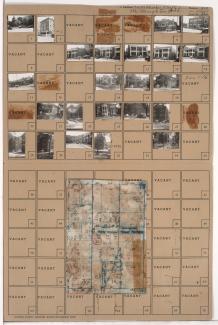
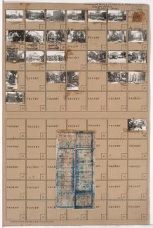
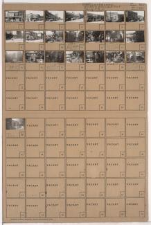
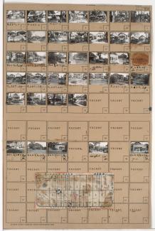
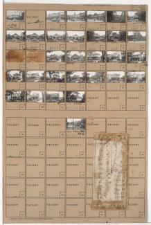
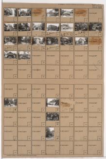
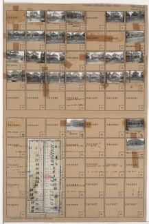
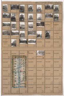
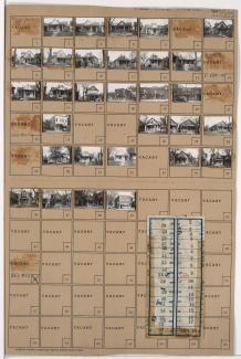
Tax Assessment Block Folder, Kansas City, MO, District 11, Block 298

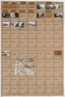
Folder contains photographs of residences, businesses, and other buildings in the Westport neighborhood, from Westport Road south to Archibald Avenue, and Mill Creek Parkway (later Broadway) east to Central Street. Westport Avenue Bank, at Westport and Mill Creek Parkway, and Broadway Hardware Company, at 311 Westport, are among the buildings pictured. Folder also includes a plat map of the block.

Tax Assessment Block Folder, Kansas City, MO, District 11, Block 25

Folder contains photographs of residences, businesses, and apartment buildings in the North Hyde Park neighborhood, from Linwood Boulevard south to 33rd Street, and Harrison Street east to Troost Avenue, including sections of 32rd Terrace and Cherry Lane. The Carlton Hotel, at 1007-1009 East Linwood, and the Blue Bird Cafeteria, at 3210 Troost, are among the buildings pictured. Folder also includes a plat map of the block.

Tax Assessment Block Folder, Kansas City, MO, District 11, Block 268

Folder contains photographs of residences, businesses, and other buildings in the South Hyde Park neighborhood, from Brush Creek Boulevard south to 47th Street, and Harrison Street east to Troost Avenue. Park National Bank, at 4628 Troost, is among the buildings pictured. Miller Screen Company, at 4602-4604 Troost, Penny's Place, at 4606 Troost,

Tax Assessment Block Folder, Kansas City, MO, District 9, Block 237

Folder contains photographs of residences, businesses, and apartment buildings in the Oak Park Northwest neighborhood, from 38th Street south to 39th Street, and Prospect Avenue east to Montgall Avenue. A Kroger grocery store, at 39th and Prospect, is among the buildings pictured. Folder also includes a plat map of the block.

Tax Assessment Block Folder, Kansas City, MO, District 9, Block 228

Folder contains photographs of residences and businesses in the Oak Park Northwest neighborhood, from 36th Street south to 37th Street, and College Avenue east to Indiana Avenue. Maryland Grocery Company, at 37th and Indiana, is among the buildings pictured. Folder also includes a plat map of the block.

Tax Assessment Block Folder, Kansas City, MO, District 11, Block 195

Folder contains photographs of residences, businesses, and other buildings in the Volker neighborhood, from 38th Street south to 39th Street, and State Line Road east to Bell Street. Johnson Hardware, at 1800 West 39th, and Rainbow Grocery Company, at 1802 West 39th, are among the buildings pictured.

Tax Assessment Block Folder, Kansas City, MO, District 8, Block 272

Folder contains photographs of residences, businesses, and apartment buildings in the Santa Fe neighborhood, from 30th Street south to 31st Street, and Prospect Avenue east to Montgall Avenue. Anchor Hardware, at 31st and Montgall, is among the buildings pictured. Folder also includes a plat map of the block.

Tax Assessment Block Folder, Kansas City, MO, District 8, Block 170

Folder contains photographs of residences and businesses in the Washington Wheatley neighborhood, from 26th Street south to 27th Street, and Indiana Avenue east to Bales Avenue. The E. H. Zirkle Company, at 3718 East 27th, Cohen's Shoe Shop, and Wilson's Tavern, at 3414 East 27th, are among the buildings pictured. at 3416 East 27th, Folder also includes a plat map of the block.