Tax Assessment Block Folder, Kansas City, MO, District 6, Block 166
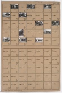
Folder contains photographs of residences in the Blue Valley neighborhood, from 17th Street south to 18th Street, and Hardesty Avenue east to Oakley Avenue.
Street Names
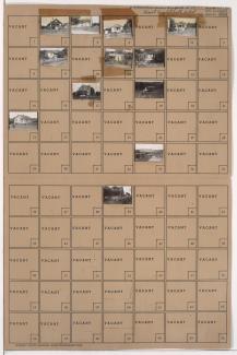
Folder contains photographs of residences in the Blue Valley neighborhood, from 17th Street south to 18th Street, and Hardesty Avenue east to Oakley Avenue.

Folder contains a photograph of a residence in the Blue Valley neighborhood, from 18th Street south to 19th Street, and Hardesty Avenue east to Oakley Avenue.

Folder contains photographs of residences in the Blue Valley neighborhood, from 19th Street south to 20th Street, and Hardesty Avenue east to Topping Avenue.

Folder contains photographs of residences in the Blue Valley neighborhood, from 20th Street south to 22nd Street, and Drury Avenue east to Oakley Avenue.

Folder contains photographs of residences in the Blue Valley neighborhood, from 20th Street south to 22nd Street, and Oakley Avenue east to Topping Avenue.

Folder contains photographs of residences in the Blue Valley neighborhood, from 22nd Street south to 23rd Street, and Oakley Avenue east to Lawndale Avenue.

Folder contains photographs of residences and businesses in the Central Blue Valley neighborhood, from 17th Street south to 18th Street, and Topping Avenue east to Bellaire Avenue. Graham's Market, at 17th and Topping, is among the buildings pictured. Folder also contains a plat map of the block.

Folder contains photographs of residences and other buildings in the Central Blue Valley neighborhood, from 18th Street south to 19th Street, and Topping Avenue east to White Avenue. Folder also contains a plat map of the block.
Folder contains photographs of residences and other buildings in the Central Blue Valley neighborhood, from 17th Street south to 23rd Street, and Belmont Avenue east to Bennington Avenue, and containing sections of Fremont Avenue, Beacon Avenue, and 18th Street.

Folder contains photographs of residences in the Blue Valley neighborhood, from 17th and 18th Streets south to the Blue River and 19th Street, and from the railroad tracks east to Eastern and Winchester Avenues, including a section of Bristol Avenue. Folder also contains plat map of the block, which can be viewed below.

Map of block in the Blue Valley neighborhood, from 17th and 18th Streets south to the Blue River and 19th Street, and from the railroad tracks east to Eastern and Winchester Avenues, including a section of Bristol Avenue, containing information about tax assessment values of included properties, and illustrating lot numbers for the block. Photographs of properties on the block can be viewed below.

Folder contains photographs of residences in the Central Blue Valley neighborhood, from 19th Street south to 20th Street, and Ewing Avenue east to Cambridge Avenue. Folder also includes a plat map of the block.

Folder contains photographs of residences in the Central Blue Valley neighborhood, from 19th Street south to 20th Street, and Newton Avenue east to Ewing Avenue. Folder also includes a plat map of the block.