Folder contains a photograph of Ruppert Stadium (later Municipal Stadium) in the Wendell Phillips neighborhood, from 21st Street south to 22nd Street, and Euclid Avenue east to Brooklyn Avenue.
Street Names
Folder contains a photograph of Ruppert Stadium (later Municipal Stadium) in the Wendell Phillips neighborhood, from 21st Street south to 22nd Street, and Euclid Avenue east to Brooklyn Avenue.
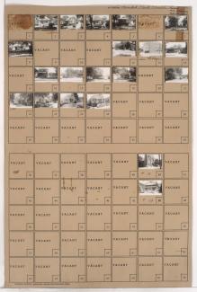
Folder contains photographs of residences, businesses, and apartment buildings in the Old Hyde Park neighborhood, from 38th Street south to 39th Street, and Broadway Boulevard east to Central Street. Berkeley Hotel, at 315 East 38th, is among the buildings pictured.
Folder contains photographs of residences, businesses, and apartment buildings in the Old Hyde Park neighborhood, from 33rd Street south to 34th Street, and Main Street east to Warwick Trafficway. Folder also includes a plat map of the block.
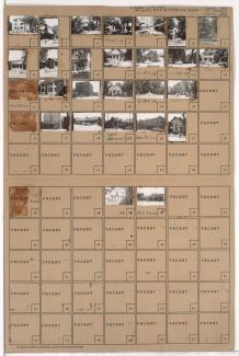
Folder contains photographs of businesses and other buildings in the Northeast Industrial District, in an area bound on the south primarily by Wilson Avenue, the city limits on the east, and containing the Alton and Kansas City Southern rail lines. Gray's Stadium baseball field is among the facilities pictured.
Folder contains photographs of residences, businesses, and a church in the Budd Park Place subdivision, from Scarritt Avenue south to St. John Avenue, and Quincy Avenue east to Denver Avenue. Holy Cross Roman Catholic Church, at 5100 St. John Avenue, is among the buildings pictured.