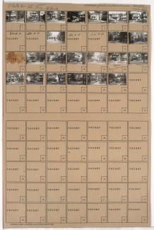
Tax Assessment Block Folder, Kansas City, MO, District 12, Block 197

Folder contains photographs of residences in the Western 49-63 neighborhood, from 58th Street south to 59th Street, and Holmes Street east to Charlotte Street.
Street Names
Folder contains photographs of residences in the Western 49-63 neighborhood, from 58th Street south to 59th Street, and Holmes Street east to Charlotte Street.

Folder contains photographs of residences in the Western 49-63 neighborhood, from 58th Street south to 58th Street, and Oak Street east to Locust Street. Folder also includes a plat map of the block.

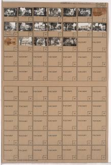
Folder contains photographs of residences in the Western 49-63 neighborhood, from 58th Street south to 59th Street, and Locust Street east to Cherry Street.

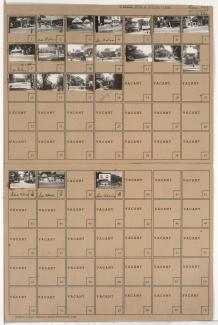
Folder contains photographs of residences in the Western 49-63 neighborhood, from 58th Street south to 59th Street, and Kenwood Avenue east to Holmes Street.
Folder contains photographs of residences in the Western 49-63 neighborhood, from 59th Street south to 60th Street, and Locust Street east to Cherry Street.

Folder contains photographs of residences in the Western 49-63 neighborhood, from 58th Street south to 59th Street, and Charlotte Street east to Rockhill Road.

Folder contains photographs of residences in the Western 49-63 neighborhood, from 58th Street south to 59th Street, and Harrison Street east to Troost Avenue. Folder also includes a plat map of the block.

Folder contains photographs of residences in the Western 49-63 neighborhood, from 58th Street south to 59th Street, and Rockhill Road east to Harrison Street.
Folder contains photographs of residences and businesses in the Western 49-63 neighborhood, from 59th Street south to 60th Street, and Harrison Street east to Troost Avenue. Bumper Ice House, at 5910 Troost, is among the buildings pictured.
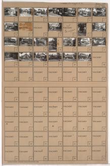
Folder contains photographs of residences in the Western 49-63 neighborhood, from 58th Street south to 59th Street, and Cherry Street east to Kenwood Avenue.

Folder contains photographs of residences in the Western 49-63 neighborhood, from 59th Street south to 60th Street, and Charlotte Street east to Rockhill Road.

Folder contains photographs of residences in the Western 49-63 neighborhood, from 59th Street south to 60th Street, and Holmes Street east to Charlotte Street.

Folder contains photographs of residences in the Western 49-63 neighborhood, from 59th Street south to 60th Street, and Rockhill Road east to Harrison Street.

Folder contains photographs of residences and businesses in the Western 49-63 neighborhood, from 59th Street south to 60th Street, and Kenwood Avenue east to Holmes Street.

Folder contains photographs of residences in the Western 49-63 neighborhood, from 59th Street south to 63rd Street, and Cherry Street east to Kenwood Avenue.

Folder contains photographs of residences in the Western 49-63 neighborhood, from 59th Street south to 60th Street, and Oak Street east to Locust Street.
Folder contains photographs of residences in the Wornall Homestead neighborhood, from 59th Street south to Huntington Road, and Wornall Road east to Central Street.

Folder contains photographs of residences in the Brookside Plaza neighborhood, from 58th Street south to 59th Street, and McGee Street east to Oak Street.

Folder contains photographs of residences and other businesses in the Brookside neighborhood, from 58th Street south to 59th Street, and Main Street east to Grand Avenue, including a section of Brookside Boulevard. Folder also includes a plat map of the block.

Folder contains photographs of residences in the Brookside Plaza neighborhood, from 58th Street south to 59th Street, and Grand Avenue east to McGee Street.