Tax Assessment Block Folder, Kansas City, MO, District 17, Block 122

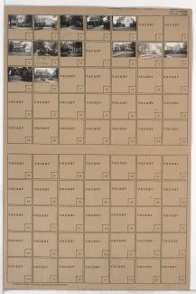
Folder contains photographs of residences in the Armour Fields neighborhood, from 65th Street south to 66th Terrace, and Summit Street east to Jefferson Street.
Street Names
Folder contains photographs of residences in the Armour Fields neighborhood, from 65th Street south to 66th Terrace, and Summit Street east to Jefferson Street.
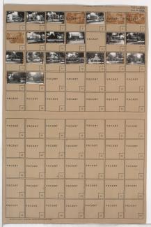
Folder containsphotographs of residences in the Armour Fields neighborhood, from 65th Street south to 66th Terrace, and Valley Road east to Summit Street.

Folder contains photographs of residences in the Armour Fields neighborhood, from 66th Terrace south to 67th Street, and Ward Parkway east to Valley Road. Folder also includes a plat map of the block.

Folder contains photographs of residences in the Armour Fields neighborhood, from 66th Terrace south to 67th Street, and Valley Road east to Pennsylvania Avenue.

Folder contains photographs of residences in the Armour Fields neighborhood, from 68th Terrace south to 69th Street, and Ward Parkway east to Valley Road.

Folder contains photographs of residences in the Armour Fields neighborhood, from 67th Street south to 67th Terrace, and Pennsylvania Avenue east to Wornall Road.

Folder contains photographs of residences in the Armour Fields neighborhood, from 67th Street south to 67th Terrace, and Valley Road east to Pennsylvania Avenue.

Folder contains photographs of residences in the Armour Fields neighborhood, from 67th Terrace south to 68th Terrace, and Ward Parkway east to Valley Road. Folder also includes a plat map of the block.

Folder contains photographs of residences in the Armour Fields neighborhood, from 67th Terrace south to 68th Street, and Valley Road east to Pennsylvania Avenue.

Folder contains photographs of residences in the Armour Fields neighborhood, from 67th Terrace south to 68th Street, and Pennsylvania Avenue east to Wornall Road.
Folder contains photographs of residences in the Armour Fields neighborhood, from 68th Street south to 68th Terrace, and Pennsylvania Avenue east to Wornall Road.

Folder contains photographs of residences in the Armour Fields neighborhood, from 68th Terrace south to 69th Street, and Pennsylvania Avenue east to Wornall Road.
Folder contains photographs of residences in the Armour Fields neighborhood, from 68th Street south to 69th Street, and Valley Road east to Pennsylvania Avenue.

Folder contains photographs of residences in the Armour Fields neighborhood, from 66th Terrace south to 67th Street, and Pennsylvania Avenue east to Wornall Road.

Folder contains a photograph of Southwest High School in the Armour Fields neighborhood, from 65th Street south to 66th Terrace, and Pennsylvania Avenue east to Wornall Road. Southwest High School is located at 6512 Wornall Road. Folder also includes a plat map of the block.

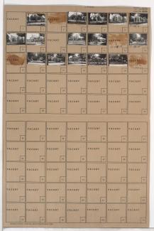
Folder contains photographs of residences in the Armour Fields neighborhood, from 65th Street south to 66th Terrace, and Jefferson Street east to Pennsylvania Avenue.

Folder contains photographs of residences in the Armour Fields neighborhood, from 69th Terrace south to Romany Road, and Ward Parkway east to Valley Road.

Folder contains photographs of residences in the Armour Fields neighborhood, from 69th Street south to Arno Road and Ward Parkway east to Arno.

Folder contains photographs of residences in the Armour Fields neighborhood, from Arno Road and 69th Street south to 69th Terrace, and Ward Parkway east to Valley Road. Folder also includes a plat map of the block.

Folder contains photographs of residences in the Armour Fields neighborhood, from 69th Street south to 69th Terrace and Valley Road east to Pennsylvania Avenue.