Maps

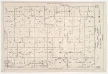
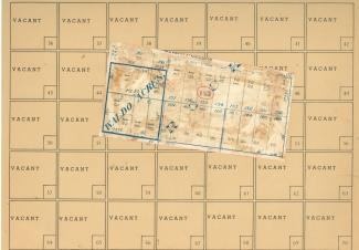
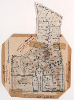
District No. 60 North Central (Ranges 29 & 30, Township 50) Map, Jackson County, Missouri

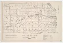
Detail maps of the north central section of District 60 of the 1940 tax assessment project. Map illustrates block numbers, appraised values, and plat boundaries, as well as streets, railroads, and rivers. Map covers an area of northeastern Jackson County, east to the Lafayette County line and north of Burgess and Doris Neeb Roads, and including the city of Buckner.

District No. 60 Central (Ranges 29 & 30, Township 49) Map, Jackson County, Missouri

Detail maps of the central section of District 60 of the 1940 tax assessment project. Map illustrates block numbers, appraised values, and plat boundaries, as well as streets and railroads. Map covers an area of southwestern Jackson County, from Burgess and Doris Neeb Roads south to U.S. Highway 40, and roughly Highway 7 east to the Lafayette County line.

Tax Assessment Block Map, Kansas City, MO, District 17, Block 183

Map of block in the Rockhill Gardens neighborhood, from 72nd Terrace south to 73rd Street, and Oak Street east to Cherry Street, containing information about tax assessment values of included properties, and illustrating lot numbers for the block. Photographs of properties on the block can be viewed below.

Tax Assessment Block Map, Kansas City, MO, District 17, Block 108

Map of block in the Country Club District, from Greenway Terrace south to Meyer Boulevard, and Ward Parkway east to Valley Road, containing information about tax assessment values of included properties, and illustrating lot numbers for the block. Photographs of properties on the block can be viewed below.

Tax Assessment Block Map, Kansas City, MO, District 8, Block 215

Map of block in the Washington Wheatley neighborhood, from 23rd Street south to 24th Street, and College Avenue east to Indiana Avenue, containing information about tax assessment values of included properties, and illustrating lot numbers for the block. Photographs of properties on the block can be viewed below.

Tax Assessment Block Map, Kansas City, MO, District 10, Block 179

Map of block in the Manheim Park neighborhood, from 42nd Street south to 43rd Street, and Troost Avenue east to Forest Avenue, containing information about tax assessment values of included properties, and illustrating lot numbers for the block. Photographs of properties on the block can be viewed below.

Tax Assessment Block Map, Kansas City, MO, District 14, Block 197

Map of block in the North Town Fork Creek neighborhood, from 55th Street south to 57th Street, and Bales Avenue east to Swope Parkway, including sections of Askew Avenue and 56th Street, containing information about tax assessment values of included properties, and illustrating lot numbers for the block. Photographs of properties on the block can be viewed below.

Tax Assessment Block Map, Kansas City, MO, District 14, Block 158

Map of block in the North Town Fork Creek neighborhood, from 51st Street south to 53rd Street, and Indiana Avenue east to Swope Parkway, containing information about tax assessment values of included properties, and illustrating lot numbers for the block. Photographs of properties on the block can be viewed below.

Tax Assessment Block Map, Kansas City, MO, District 14, Block 42

Map of block in the North Town Fork Creek neighborhood, from 51st Street south to 53rd Street, and Swope Parkway east to Cleveland Avenue, containing information about tax assessment values of included properties, and illustrating lot numbers for the block. Photographs of properties on the block can be viewed below.

Tax Assessment Block Map, Kansas City, MO, District 20G, Block 198

Map of block in the the Santa Fe Hills neighborhood south of the 1940 Kansas City city limits, from Sweeney Boulevard south to 89th Street, and Wornall and Hiawatha Roads east to Daniel Boone Road, including Huron Circle, containing information about tax assessment values of included properties, and illustrating lot numbers for the block. Photographs of properties on the block can be viewed below.