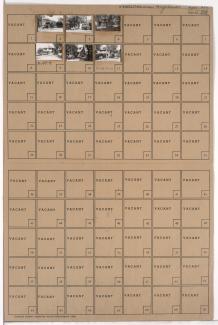
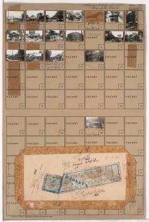
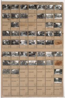
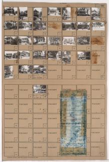
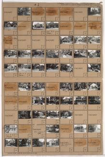
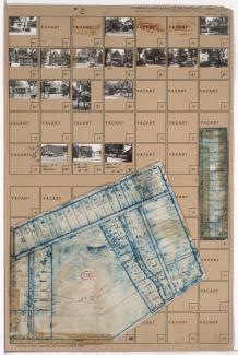
Tax Assessment Block Folder, Kansas City, MO, District 11, Block 143
Folder contains photographs of residences in the Coleman Highlands neighborhood, from 31st Street south to 32nd Street, and Holly Street east to Coleman Road and Karnes Boulevard.
Folder contains photographs of residences in the Coleman Highlands neighborhood, from 32nd Street south to 33rd Street, and Holly Street east to Coleman Road.
Folder contains a photograph of a residence in the Coleman Highlands neighborhood, from 31st Street south to 32nd Street, and Mercier Street east to Holly Street.
Folder contains photographs of residences and industrial buildings in the Coleman Highlands neighborhood, from 31st and 32nd Streets south to Karnes Boulevard, and from the railroad tracks east to Terrace and Holly Streets, including sections of Bullene and Fairmount Streets.
Folder contains photographs of residences and businesses in the West Plaza neighborhood, from 47th Street south to 48th Street, and Holly Street east to Jarboe Street. Folder also includes a plat map of the block.
Folder contains photographs of residences and businesses in the West Plaza neighborhood, from 47th Street south to 48th Street, and Mercier Street east to Holly Street. Folder also includes a plat map of the block.
Folder contains photographs of residences in the West Plaza neighborhood, from 48th Street south to 49th Street, and Mercier Street east to Holly Street. Folder also includes a plat map of the block.
Folder contains photographs of residences in the West Plaza neighborhood, from 48th Street south to 49th Street, and Holly Street east to Jarboe Street. Folder also includes a plat map of the block.
Folder contains photographs of residences in the Westwood neighborhood, from 49th Street south to Ward Parkway, and Holly Street east to Jarboe Street. Folder also includes a plat map of the block.
Folder contains photographs of residences in the Westwood neighborhood, from 49th Street south to 50th Street and Westwood Road, and Mercier Street east to Holly Street. Folder also includes a plat map of the block.
Folder contains photographs of residences in the Volker neighborhood, from 40th Street south to 41st Street, and Mercier Street east to Holly Street.
Folder contains photographs of residences and apartment buildings in the Volker neighborhood, from 40th Street south to 41st Street, and Holly Street east to Roanoke Road.
Folder contains photographs of residences, businesses, and other buildings in the Volker neighborhood, from 41st Street south to 41st Terrace, and Holly Street east to Roanoke Road. Folder also includes a plat map of the block.
Folder contains photographs of residences in the Volker neighborhood, from 41st Terrace south to 42nd Street, and Holly Street east to Roanoke Road, including a section of 41st Place. Folder also includes a plat map of the block, which can be viewed below.
Map of block in the the Volker neighborhood, from 41st Terrace south to 42nd Street, and Holly Street east to Roanoke Road, including a section of 41st Place, containing information about tax assessment values of included properties, and illustrating lot numbers for the block. Photographs of properties on the block can be viewed below.
Folder contains photographs of residences and apartment buildings in the Volker neighborhood, from 41st Street south to 42nd Street, and Mercier Street east to Holly Street.
Folder contains photographs of residences in the West Plaza neighborhood, from 43rd Street/Westport Road south to 44th Street, and Holly Street east to Jarboe Street.
Folder contains photographs of residences, businesses, and apartment buildings in the Volker neighborhood, from 42nd Street south to 43rd Street/Westport Road, and Mercier Street east to Holly Street. Bradley's Filling Station, at 1200 Westport Road, is among the buildings pictured. Folder also includes a plat map of the block.
One of two folders containing photographs of residences and other buildings in the Westport neighborhood, from 42nd Street south to 43rd Street and Westport Road, and Holly Street east to Roanoke Road, including sections of Wiedenmann Place and Greenwood Place. Kansas City Boys' Orphan Home, at 924-1010 Westport, is among the buildings pictured. A plat map of the block can be seen at http://cdm.sos.mo.gov/u?/kcpltax,3450.
Second of two folders containing photographs of residences and other buildings in the Westport neighborhood, from 42nd Street south to 43rd Street and Westport Road, and Holly Street east to Roanoke Road, including sections of Wiedenmann Place and Greenwood Place.