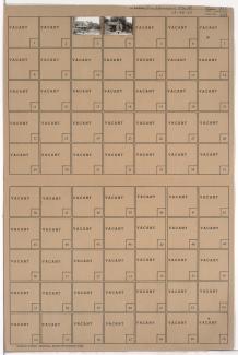
Tax Assessment Block Folder, Kansas City, MO, District 11, Block 145

Folder contains photographs of residences in the Coleman Highlands neighborhood, from 32nd Street south to 32nd Terrace, and Coleman Road east to Karnes Boulevard.
Street Names
Folder contains photographs of residences in the Coleman Highlands neighborhood, from 32nd Street south to 32nd Terrace, and Coleman Road east to Karnes Boulevard.

Folder contains photographs of residences in the Coleman Highlands neighborhood, from 32nd Terrace south to 33rd Street, and Coleman Road east to Karnes Boulevard. The Koppen Residence, at 910 West 33rd, is among the buildings pictured.

Folder contains photographs of residences in the Volker neighborhood, from 32nd Street south to 32nd Terrace, and Bell Street east to Roanoke Road.
Folder contains photographs of residences in the Volker neighborhood, from 32nd Terrace south to 33rd Street, and Bell Street east to Roanoke Road.
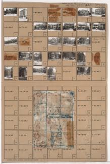
Folder contains photographs of residences, businesses, and apartment buildings in the North Hyde Park neighborhood, from Linwood Boulevard south to 33rd Street, and Harrison Street east to Troost Avenue, including sections of 32rd Terrace and Cherry Lane. The Carlton Hotel, at 1007-1009 East Linwood, and the Blue Bird Cafeteria, at 3210 Troost, are among the buildings pictured. Folder also includes a plat map of the block.

Folder contains photographs of residences and other buildings in the Old Hyde Park neighborhood, from Linwood Boulevard south to 32nd Terrace, and Warwick Boulevard east to McGee Street.

Folder contains photographs of residences and apartment buildings in the Old Hyde Park neighborhood, from 32nd Terrace south to 33rd Street, and Warwick Boulevard east to McGee Street. Folder also includes a plat map of the block.