Tax Assessment Block Folder, Kansas City, MO, District 1, Block 15

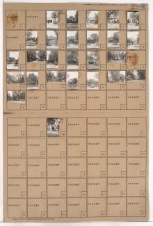
Folder contains photographs of residences in the Clifton Heights addition, from Gladstone Boulevard south to Saida Avenue, and Drury Avenue east to Oakley Avenue.
Street Names
Folder contains photographs of residences in the Clifton Heights addition, from Gladstone Boulevard south to Saida Avenue, and Drury Avenue east to Oakley Avenue.

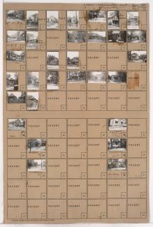
Folder contains photographs of residences and businesses in the Sheffield neighborhood, from 11th Street south to 12th Street, and Oakley Avenue east to Topping Avenue.

Folder contains photographs of residences and other buildings in the Sheffield neighborhood, from 9th Street south to 10th Street, and Hardesty Avenue east to Oakley Avenue, including a section of Winner Road.

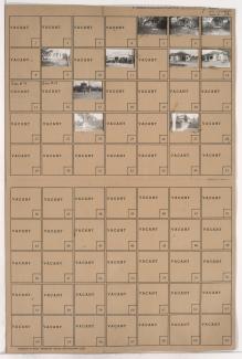
Folder contains photographs of residences in the Sheffield neighborhood, from 10th Street south to 11th Street, and Hardesty Avenue east to Oakley Avenue, including a section of Winner Road.
Folder contains photographs of residences and other buildings in the Sheffield neighborhood, from Winner Road south to 10th Street, and Oakley Avenue east to Topping Avenue.
Folder contains photographs of residences and businesses in the Sheffield neighborhood, from 10th Street south to 11th Street, and Oakley Avenue east to Topping Avenue.

Folder contains photographs of residences in the Sheffield neighborhood, from 11th Street south to 12th Street, and Hardesty Avenue east to Oakley Avenue.

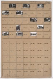
Folder contains photographs of residences and other buildings in the West Blue Valley neighborhood, from 12th Street south to 14th Street, and Oakley Avenue east to Lawndale Avenue.
Folder contains photographs of residences and other buildings in the West Blue Valley neighborhood, from 14th Street south to 15th Street (later Truman Road), and Oakley Avenue east to Lawndale Avenue.

Folder contains photographs of residences in the West Blue Valley neighborhood, from 12th Street south to 14th Street, and Drury Avenue east to Oakley Avenue.

Folder contains photographs of residences and businesses in the West Blue Valley neighborhood, from 14th Street south to 15th Street (later Truman Road), and Drury Avenue east to Oakley Avenue.
Folder contains photographs of residences in the Blue Valley neighborhood, from 17th Street south to 18th Street, and Hardesty Avenue east to Oakley Avenue.

Folder contains a photograph of a residence in the Blue Valley neighborhood, from 18th Street south to 19th Street, and Hardesty Avenue east to Oakley Avenue.

Folder contains photographs of residences in the Blue Valley neighborhood, from 20th Street south to 22nd Street, and Drury Avenue east to Oakley Avenue.

Folder contains photographs of residences in the Blue Valley neighborhood, from 20th Street south to 22nd Street, and Oakley Avenue east to Topping Avenue.

Folder contains photographs of residences in the Blue Valley neighborhood, from 22nd Street south to 23rd Street, and Drury Avenue east to Oakley Avenue.

Folder contains photographs of residences in the Blue Valley neighborhood, from 22nd Street south to 23rd Street, and Oakley Avenue east to Lawndale Avenue.

Folder contains photographs of residences in the West Blue Valley neighborhood, from 16th Terrace south to 17th Street, and Hardesty Avenue east to Oakley Avenue.

Folder contains photographs of residences in the West Blue Valley neighborhood, from 16th Street south to 16th Terrace, and Hardesty Avenue east to Oakley Avenue, including a section of Drury Avenue.

Folder contains photographs of residences and other buildings in the West Blue Valley neighborhood, from 15th Street (later Truman Road) south to 16th Street, and Drury Avenue east to Oakley Avenue. Folder also contains plat map of the block.