
Folder contains photographs of residences in the Scarritt Point neighborhood, from Sunrise Drive south to Norledge Avenue, and Mersington Avenue east to Jackson Avenue, including a segment of Clinton Place.
Search

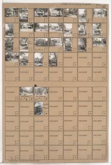
Folder contains photographs of residences and apartment buildings in the McKinney Heights subdivision, from Norledge Avenue south to Scarritt Avenue, and Mersington Avenue and Gladstone Boulevard east to Clinton Place.

Folder contains photographs of residences in the McKinney Heights subdivision, from Norledge Avenue south to Scarritt Avenue, and Clinton Place east to Jackson Avenue.
Street Names

Folder contains photographs of residences in the McKinney Heights subdivision, from Scarritt Avenue south to Windsor Avenue, and Clinton Place east to Jackson Avenue.
Street Names

Folder contains photographs of residences in the McKinney Heights subdivision, from Scarritt Avenue south to Windsor Avenue, and Mersington Avenue east to Clinton Place.
Street Names
Folder contains photographs of residences, apartment buildings, and businesses in the McKinney Heights subdivision, from Windsor Avenue south to St. John Avenue, and Mersington Avenue east to Clinton Place. Shelton Motor Service, at 3922 St. John, is among the buildings pictured.
Street Names

Folder contains photographs of residences and businesses in the McKinney Heights subdivision, from Windsor Avenue south to St. John Avenue, and Clinton Place east to Jackson Avenue.
Street Names

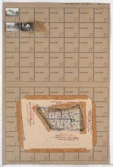
Folder contains photographs of residences in the Santa Fe Hills neighborhood south of the 1940 Kansas City city limits, from Rainbow Lane south to Sweeney Boulevard, and Hiawatha Road east to Daniel Boone Road. Folder also includes a plat map of the block.
Street Names
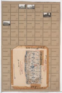
Folder contains photographs of residences in the Santa Fe Hills neighborhood south of the 1940 Kansas City city limits, from Sweeney Boulevard south to Porte Cima Pas and east to Rainbow Lane. Folder also includes a plat map of the block.
Street Names
Folder contains photographs of residences, including several under construction, in the Santa Fe Hills neighborhood south of the 1940 Kansas City city limits, from Porte Cima Pas south to 89th Street, and Rainbow Lane east to Maiden Lane. Folder also includes a plat map of the block.
Street Names
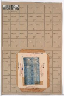
Folder contains photographs of residences in the Boone Hills neighborhood south of the 1940 Kansas City city limits, from 89th Street south to 90th Street, and Rainbow Lane east to Maiden Lane. Folder also includes a plat map of the block.
Street Names