Tax Assessment Block Folder, Kansas City, MO, District 1, Block 15

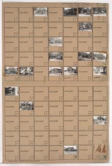
Folder contains photographs of residences in the Clifton Heights addition, from Gladstone Boulevard south to Saida Avenue, and Drury Avenue east to Oakley Avenue.
Street Names
Folder contains photographs of residences in the Clifton Heights addition, from Gladstone Boulevard south to Saida Avenue, and Drury Avenue east to Oakley Avenue.

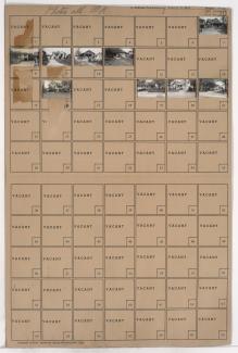
Folder contains photographs of residences in the West Blue Valley neighborhood, from 12th Street south to 14th Street, and Drury Avenue east to Oakley Avenue.
Folder contains photographs of residences and businesses in the West Blue Valley neighborhood, from 12th Street south to 15th Street (later Truman Road), and Hardesty Avenue east to Drury Avenue.

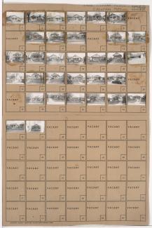
Folder contains photographs of residences and businesses in the West Blue Valley neighborhood, from 14th Street south to 15th Street (later Truman Road), and Drury Avenue east to Oakley Avenue.

Folder contains photographs of residences in the Blue Valley neighborhood, from 20th Street south to 22nd Street, and Drury Avenue east to Oakley Avenue.
Folder contains photographs of residences in the Blue Valley neighborhood, from 20th Street south to 22nd Street, and Hardesty Avenue east to Drury Avenue.

Folder contains photographs of residences in the Blue Valley neighborhood, from 22nd Street south to 23rd Street, and Hardesty Avenue east to Drury Avenue.

Folder contains photographs of residences in the Blue Valley neighborhood, from 22nd Street south to 23rd Street, and Drury Avenue east to Oakley Avenue.

Folder contains photographs of residences and businesses in the West Blue Valley neighborhood, from 15th Street (later Truman Road) south to 16th Street, and Hardesty Avenue east to Drury Avenue.

Folder contains photographs of residences in the West Blue Valley neighborhood, from 16th Street south to 16th Terrace, and Hardesty Avenue east to Oakley Avenue, including a section of Drury Avenue.

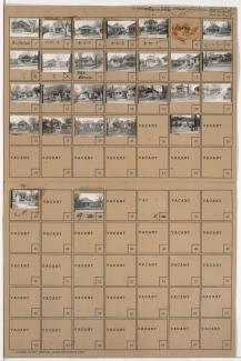
Folder contains photographs of residences and other buildings in the West Blue Valley neighborhood, from 15th Street (later Truman Road) south to 16th Street, and Drury Avenue east to Oakley Avenue. Folder also contains plat map of the block.

Folder contains photographs of residences in the Clifton Heights addition, from Norledge Place south to Scarritt Avenue, and from Drury Avenue east to Oakley Avenue.

Folder contains photographs of residences and businesses in the South Blue Valley neighborhood, from 23rd Street south to 24th Street, and Drury Avenue east to Oakley Avenue. Lakeview Market, at 5522 East 24th, is among the buildings pictured.
Folder contains photographs of residences and businesses in the South Blue Valley neighborhood, from 23rd Street south to 24th Street, and Hardesty Avenue east to Drury Avenue.
Folder contains photographs of residences and businesses in the South Blue Valley neighborhood, from 24th Street south to 25th Street, and Hardesty Avenue east to Drury Avenue. Parkview Pharmacy, at 2401 Hardesty, is among the buildings pictured.

Folder contains photographs of residences in the South Blue Valley neighborhood, from 24th Street south to 25th Street, and Drury Avenue east to Oakley Avenue.

Folder contains photographs of residences in the South Blue Valley neighborhood, from 25th Street south to 26th Street, and Drury Avenue east to Oakley Avenue.

Folder contains photographs of residences in the South Blue Valley neighborhood, from 25th Street south to 26th Street, and Hardesty Avenue south to Drury Avenue.

Folder contains photographs of residences in the South Blue Valley neighborhood, from 26th Street south to 27th Street, and Hardesty Avenue east to Drury Avenue.

Folder contains photographs of residences in the South Blue Valley neighborhood, from 26th Street south to 27th Street, and Drury Avenue east to Oakley Avenue.