Tax Assessment Block Folder, Kansas City, MO, District 12, Block 226

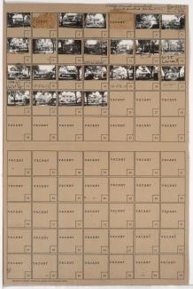
Folder contains photographs of residences in the Astor Place neighborhood, from 61st Terrace south to 62nd Street, and Oak Street east to Locust Street.
Street Names
Folder contains photographs of residences in the Astor Place neighborhood, from 61st Terrace south to 62nd Street, and Oak Street east to Locust Street.

Folder contains photographs of residences in the Astor Place neighborhood, from 61st Street south to 61st Terrace, and Cherry Street east to Holmes Street.

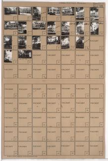
Folder contains photographs of residences in the Astor Place neighborhood, from 61st Terrace south to 62nd Street, and Cherry Street east to Kenwood Avenue.

Folder contains photographs of residences in the Astor Place neighborhood, from 61st Street south to 61st Terrace, and Oak Street east to Cherry Street.

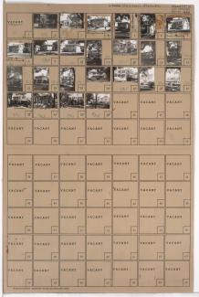
Folder contains photographs of residences in the Astor Place neighborhood, from 61st Terrace south to 62nd Street, and Kenwood Avenue east to Holmes Street.

Folder contains photographs of residences in the Wornall Homestead neighborhood, from 61st Street south to 61st Terrace, and Wornall Road east to Brookside Boulevard. The John B. Wornall House, at 6115 Wornall, is among the buildings pictured.
Folder contains photographs of residences in the Wornall Homestead neighborhood, from 61st Terrace south to 62nd Street, and Wornall Road east to Brookside Boulevard.

Folder contains photographs of residences in the Morningside neighborhood, from 61st Terrace south to 62nd Street, and Brookside Boulevard east to Main Street.

Folder contains photographs of residences in the Morningside neighborhood, from 61st Street south to 61st Terrace, and Brookside Boulevard east to Main Street.
Folder contains photographs of residences in the Greenway Fields neighborhood, from 61st Terrace south to 62nd Street, and Summit Street east to Valley Road and Pennsylvania Avenue.

Folder contains photographs of residences in the Greenway Fields neighborhood, from 61st Street south to 61st Terrace, and Pennsylvania Avenue east to Wornall Road.
Folder contains photographs of residences in the Greenway Fields neighborhood, from 61st Street south to 61st Terrace, and Summit Street east to Pennsylvania Avenue.

Folder contains photographs of residences in the Hampstead Gardens neighborhood, from 61st Street south to 61st Terrace, and Ward Parkway east to Summit Street.

Folder contains photographs of residences in the Stratford Gardens neighborhood, from 61st Terrace south to 62nd Street, and State Line Road east to Ward Parkway. Folder also includes a plat map of the block.

Folder contains photographs of residences in the Stratford Gardens neighborhood, from 61st Street south to 61st Terrace, and State Line Road east to Ward Parkway.

Folder contains photographs of residences in the Country Club District, from 61st Terrace south to 62nd Street, and Ward Parkway east to Summit Street. Folder also includes a plat map of the block.

Folder contains photographs of residences in the Greenway Fields neighborhood, from 61st Terrace south to 62nd Street, and Pennsylvania Avenue east to Wornall Road. Folder also includes a plat map of the block.