Tax Assessment Block Folder, Kansas City, MO, District 7, Block 228

Folder contains photographs of businesses in the Leeds neighborhood, from 37th Street south to 39th Street, and Bennington Avenue east to Raytown Road.
Street Names
Folder contains photographs of businesses in the Leeds neighborhood, from 37th Street south to 39th Street, and Bennington Avenue east to Raytown Road.

Folder contains photographs of residences in the Eastwood Hills neighborhood, south of 47th Street and west of Eastern Avenue.

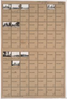
Folder contains photographs of buildings in the Eastwood Hills neighborhood, from 39th Street south to 40th Street, and Ewing Avenue east to the railroad tracks. Folder also includes a plat map of the block.

Folder contains a photograph of a building in the Eastwood Hills neighborhood, from 43rd Street south to 47th Street, and Topping Avenue east to Bennington Avenue.
Folder contains photographs of residences, businesses, and other buildings in the Eastwood Hills neighborhood, from 39th Street south to 40th Street, and Fuller Avenue east to Ewing Avenue, including a section of Bennington Avenue.

Folder contains a photograph of a residence in the Eastwood Hills neighborhood, from 39th Street south to 40th Street, and the railroad tracks east to Winchester Avenue.

First of two folders containing photographs of residences and other buildings in the Eastwood Hills neighborhood, south of 40th Street, and from Ewing Avenue east to the Kansas City city limits.

Second of two folders containing photographs of residences and other buildings in the Eastwood Hills neighborhood, south of 40th Street, and from Ewing Avenue east to the Kansas City city limits.

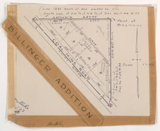
Folder contains photographs of residences and other buildings in the Brown Estates neighborhood, east of the 1940 Kansas City city limits, adjacent to Coal Mine Road and south of 51st Street.

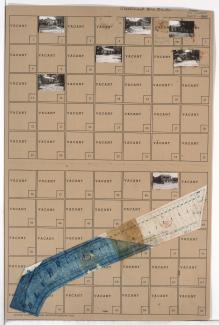
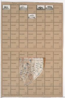
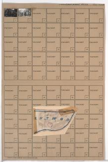
Folder contains photographs of residences and other buildings in the Eastwood Hills West neighborhood, east of the 1940 Kansas City city limits, from Coal Mine Road southwest to U.S. Highway 50. Folder also includes two plat maps of the area, which can be viewed below.
Map of an area in the Eastwood Hills West neighborhood, east of the 1940 Kansas City city limits, northeast of Coal Mine Road, containing information about tax assessment values of included properties, and illustrating lot numbers for the block.

Map of an area in the Eastwood Hills West neighborhood, east of the 1940 Kansas City city limits, from Coal Mine Road southwest to U.S. Highway 50, containing information about tax assessment values of included properties, and illustrating lot numbers for the block. Photographs of properties on the block can be viewed below.

Folder contains photographs of residences and other businesses in the Eastwood Hills West neighborhood, from the Blue River east to Brighton Avenue and north to Blue Banks Avenue, including a section of Colorado Avenue.

Folder contains photographs of residences in the Eastwood Hills West neighborhood, from 47th Street and the Blue River south to 49th Street and Sni-A-Bar Road, and the Blue River east to Kansas City's 1940 city limits, including sections of Hardesty Avenue, Coal Mine Road, and Eastwood Court.

Folder contains photographs of residences in the Eastwood Hills West neighborhood, from 47th Street south to Blue Banks Avenue, and Brighton Avenue east to the Blue River, including sections of Quincy, Denver, Colorado, and Hardesty Avenues.
Folder contains photographs of residences in the Eastwood Hills West neighborhood, from Blue Banks Road south to the Blue River, and Brighton Avenue east to Colorado Avenue. Hackett's Market, at Blue Banks and Brighton, is among the buildings pictured. Folder also includes a plat map of the block.
Folder contains photographs of residences in the Eastwood Hills neighborhood, from Sni-A-Bar Road on the north to Fairway Drive on the east, south, and east. Folder also includes a plat map of the block.

Folder contains photographs of residences in the Eastwood Hills neighborhood south of the 1940 Kansas City city limits, from the southern city limits (roughly 47th Street) south to Eastwood Court, and the eastern city limits (roughly Topping Avenue) east to Eastwood Drive.
Folder contains photographs of residences in the Eastwood Hills neighborhood south of the 1940 Kansas City city limits, from Eastwood Court south to Sni-A-Bar Road, and the city limits (roughly Topping Avenue) east to Eastwood Drive. Folder also includes a plat map of the block.

Folder contains photographs of residences in the Eastwood Hills neighborhood south of the 1940 Kansas City city limits, from Eastwood Drive southeast to Sni-A-Bar Road. Folder also includes a plat map of the block.