Tax Assessment Block Folder, Kansas City, MO, District 4, Block 168
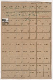
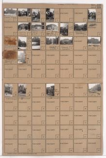
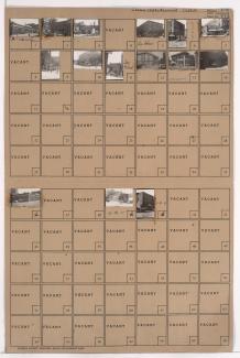
Folder contains a photograph of Municipal Auditorium in downtown Kansas City, from 13th Street south to 14th Street, and Central Street east to Wyandotte Street.
Street Names
Folder contains a photograph of Municipal Auditorium in downtown Kansas City, from 13th Street south to 14th Street, and Central Street east to Wyandotte Street.
Folder contains photographs of residences and other buildings in the Dundee Place subdivision, from 13th Street south to 14th Street, and Harrison Street east to Troost Avenue.
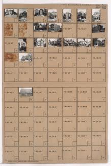
Folder contains photographs of residences, businesses, and other buildings in the Dundee Place subdivision, from 14th Street south to 15th Street (later Truman Road), and Harrison Street east to Troost Avenue. The Scottish Rite Temple, at 1024 East Truman Road, is among the buildings pictured.
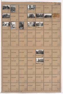
Folder contains photographs of residences, businesses, and other buildings in the Dundee Place subdivision, from 15th Street (later Truman Road) south to 16th Street, and Harrison Street east to Troost Avenue. Rossner Electric Company, at 1009-1011 East 15th, and the Second Ward Independent Democratic Club, at 1005 East 15th, are among the buildings pictured.
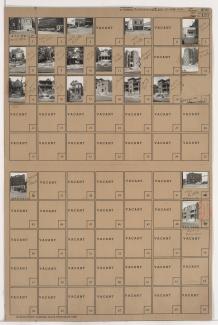
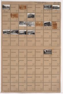
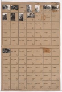
Folder contains photographs of residences, businesses, and other buildings in downtown Kansas City, from 14th Street south to 15th Street (later Truman Road), and Locust Street east to Cherry Street. The First English Lutheran Church, at 14th and Cherry, and Yelloway Garage, on Cherry, are among the buildings pictured.
Folder contains photographs of businesses and other buildings in the Crossroads District, from 17th Street south to 18th Street, and McGee Street east to Oak Street. Marshall Wholesale Auto Supply, at 1732 Oak, Osgood Coffee, at 1727 McGee, and Downtown Buick Company, on McGee, are among the buildings pictured.
Folder contains photographs of residences, apartments, and other buildings in the Downtown East neighborhood, from 15th Street (later Truman Road) south to 16th Street, and Virginia Avenue east to Lydia Avenue. The Kansas City Social Turnverein, a German social organization and athletic club at 1323-1327 East 15th, is among the buildings pictured.

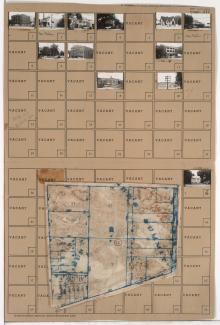
Folder contains photographs of residences, businesses, and apartment buildings in the North Hyde Park neighborhood, from 31st Street south to Linwood Boulevard, and Campbell Avenue east to Harrison Street. The Kansas City Ladies' Athenaeum Club Building, at 900 East Linwood, and the LaSalle Apartment Hotel, at Linwood and Harrison, are among the buildings pictured. Folder also includes a plat map of the block.
Folder contains photographs of businesses and other buildings in the Old Hyde Park neighborhood, from 31st Terrace south to Linwood Boulevard, and Wyandotte Street east to Main Street. The Pla-Mor Ballroom, at 3142 Main, the Joyce Funeral Home, at 3200 Main, and a Modern Woodmen of America lodge, at 114 West Linwood, are among the buildings pictured. Folder also includes a plat map of the block.
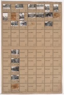
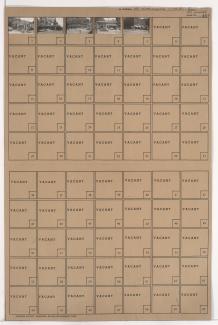
Folder contains photographs of businesses and other buildings in downtown Kansas City, from 10th Street south to 11th Street, and Central Street east to Wyandotte Street. The Ararat Shrine Temple (later Lyric Theater) at 11th and Central is among the buildings listed.
Folder contains photographs of businesses and other buildings in downtown Kansas City, from 6th Street Trafficway south to 7th Street, and Walnut Street east to Grand Avenue. The Elks Club house, at 7th and Grand, and the Western Union Telegraph Building, at 100 East 7th Street, are among the buildings pictured.
Folder contains photographs of businesses and other buildings in downtown Kansas City, from 10th Street south to 11th Street, and Grand Avenue east to McGee Street. The YWCA Building, at 1020 McGee, the Lathrop Building, at 1005 Grand, and Commerce Buffet, at 1004 McGee, are among the buildings pictured.