Tax Assessment Block Folder, Kansas City, MO, District 16, Block 114

Folder contains photographs of residences in the Walnut Grove neighborhood, from 75th Street south to 76th Street, and Brooklyn Avenue east to Olive Street.
Street Names
Folder contains photographs of residences in the Walnut Grove neighborhood, from 75th Street south to 76th Street, and Brooklyn Avenue east to Olive Street.

Folder contains photographs of residences in the Battleflood Heights neighborhood, from 74th Street south to 75th Street, and Forest Avenue east to Tracy Avenue.
Folder contains photographs of residences and businesses in the Battleflood Heights neighborhood, from 74th Street south to 75th Street, and Troost Avenue east to Forest Avenue.
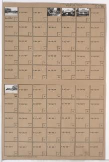
Folder contains a photograph of Marlborough School in the Battleflood Heights neighborhood, from 74th Street south to 75th Street, and Tracy Avenue east to Virginia Avenue. Marlborough School is located at 7417 Tracy.

Folder contains photographs of residences in the Walnut Grove neighborhood, from Wabash Avenue north to 75th Street and east to Prospect Avenue.

Folder contains photographs of residences in the Walnut Grove neighborhood, from 75th Street southwest to Olive Street and southeast to Wabash Avenue.

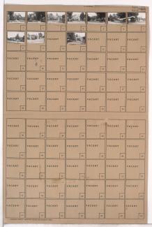
Folder contains photographs of residences in the Battleflood Heights neighborhood, from 75th Street south to 75th Terrace, and Lydia Avenue east to Paseo Boulevard.

Folder contains photographs of residences in the Battleflood Heights neighborhood, from 75th Street south to 75th Terrace, and Troost Avenue east to Lydia Avenue.
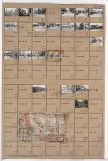
Folder contains photographs of residences in the Tower Homes neighborhood, from 73rd Street south to 75th Street, and Holmes Road east to Troost Avenue, including sections of 73rd Terrace, 74th Street, Campbell Street, and Harrison Street. Folder also includes a partial plat map of the block.
Folder contains photographs of residences in the Rockhill Gardens neighborhood, from 74th Terrace south to 75th Street, and Cherry Street east to Holmes Road. Folder also includes a plat map of the block.

Folder contains photographs of residences in the Tower Homes neighborhood, from 74th Street south to 75th Street, and Walnut Street east to Grand Avenue.

Folder contains photographs of residences in the Tower Homes neighborhood, from 74th Street south to 75th Street, and Main Street east to Walnut Street.

Folder contains photographs of residences in the Tower Homes neighborhood, from 74th Terrace south to 75th Street, and Wyandotte Street east to Main Street. St. Elizabeth's Catholic Church and School, at 75th and Main, are among the buildings pictured.

Folder contains photographs of residences in the Tower Homes neighborhood, from 74th Terrace south to 75th Street, and Grand Avenue east to Oak Street.
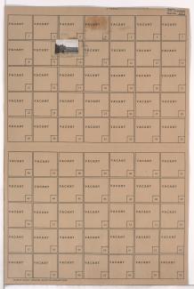
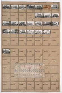
Folder contains photographs of residences and businesses in the Waldo neighborhood, from 74th Terrace south to 75th Street, and Wornall Road east to Wyandotte Street. The 8th Ward Democratic Club, at 212 West 75th, Kahle Grocery, at 214 West 75th, and Velvet Freeze Ice Cream, at 75th and Wornall, are among the buildings pictured. Folder also includes a plat map of the block.
Folder contains photographs of residences in the Tower Homes neighborhood, from 74th Terrace south to 75th Street, and Oak Street east to Cherry Street. Folder also includes a plat map of the block.

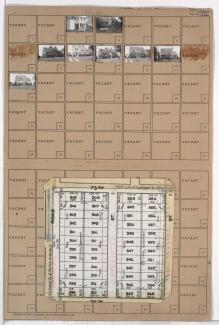
Map of block in the Tower Homes neighborhood, from from 75th Street south to 77th Street, and Main Street east to Walnut Street, containing information about tax assessment values of included properties, and illustrating lot numbers for the block. Photographs of properties on the block can be viewed below.
Folder contains photographs of residences and businesses in the Tower Homes neighborhood, from 75th Street south to 75th Terrace, and Harrison Street east to Troost Avenue.
Folder contains photographs of residences in the Tower Homes neighborhood, from 75th Street south to 76th Street, and Holmes Road east to Harrison Street, including sections of Charlotte Street and 75th Terrace. Folder also includes a plat map of the block.

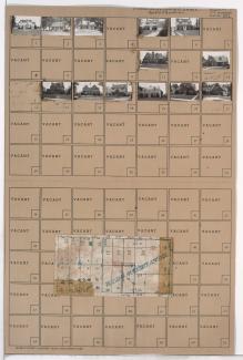
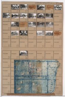
Folder contains photographs of residences in the Tower Homes neighborhood, from 75th Street south to 77th Street, and Grand Avenue east to Oak Street, including a section of McGee Street. Folder also includes a plat map of the block, which can be viewed below.