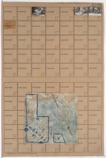
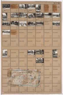
Folder contains photographs of residences in Gillham Park, from 42nd Street south to Brush Creek Boulevard, and from Gillham Road West, Rockhill Terrace, and Charlotte Street east to Gillham Road and Harrison Street, including a section of Charlotte Street. Folder also includes a partial plat map of the block.
Search
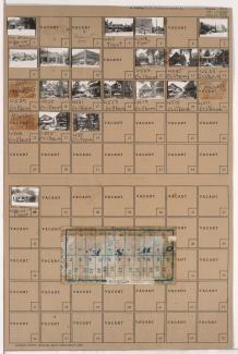
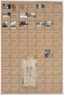
Folder contains photographs of residences, businesses, and other buildings in the South Hyde Park neighborhood, from 45th Street south to Brush Creek Boulevard, and Harrison Street and Gillham Road east to Troost Avenue. McClure-Norrington Chevrolet Company, at 4506 Troost, and Gibbs Auto Sales, at 4512 Troost, are among the buildings pictured. Folder also includes a plat map of the block.
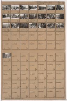
Folder contains photographs of residences, businesses, and other buildings in the South Hyde Park neighborhood, from Brush Creek Boulevard south to 47th Street, and Harrison Street east to Troost Avenue. Park National Bank, at 4628 Troost, is among the buildings pictured. Miller Screen Company, at 4602-4604 Troost, Penny's Place, at 4606 Troost,
Street Names

Folder contains photographs of residences in the Rockhill neighborhood, from Brush Creek Boulevard south to 47th Street, and Charlotte Street east to Campbell Street.
Street Names

Folder contains photographs of residences in the Rockhill neighborhood, from 45th Street south to Brush Creek Boulevard, and Holmes Street east to Charlotte Street. Folder also includes a plat map of the block.
Street Names

Folder contains photographs of residences in the Rockhill neighborhood, from Brush Creek Boulevard south to 47th Street, and Holmes Street east to Charlotte Street.
Street Names

Folder contains photographs of residences in the Rockhill neighborhood, from Brush Creek Boulevard south to 47th Street, and Rockhill Road east to Holmes Street. Folder also includes a plat map of the block.
Street Names

Folder contains photographs of residences in the Rockhill neighborhood, from 46th Street south to Brush Creek Boulevard, and Rockhill Road east to Holmes Street. Folder also includes a plat map of the block.
Street Names
Folder contains a photograph of the Nelson-Atkins Museum of Art, at 4525 Oak, in the Southmoreland neighborhood. Block covers 45th Street south to Brush Creek Boulevard (later Emanuel Clever II Boulevard), and Warwick Boulevard east to Rockhill Road, including a section of Oak Street.

Folder contains photographs of residences in the Southmoreland neighborhood, from Brush Creek Boulevard south to 47th Street, and Oak Street east to Rockhill Road. Folder also includes a plat map of the block.
Street Names

Folder contains photographs of residences, businesses, and apartment buildings in the Manheim Park neighborhood, from 46th Street south to 47th Street, and Tracy Avenue east to Virginia Avenue. Parkview Pharmacy, at 46th and Virginia, is among the buildings pictured. Folder also includes a plat map of the block.

Folder contains photographs of residences and other buildings in the Ivanhoe Southeast neighborhood, from 45th Street south to 46th Street, and Paseo Boulevard east to Woodland Avenue.
Folder contains photographs of residences, businesses, and apartment buildings in the Manheim Park neighborhood, from 45th Street south to 46th Street, and Virginia Avenue east to Paseo Boulevard. Folder also includes a plat map of the block.

Folder contains photographs of residences and apartment buildings in the Manheim Park neighborhood, from 45th Street south to 46th Street, and Forest Avenue east to Tracy Avenue. Folder also includes a plat map of the block.
Street Names
Folder contains photographs of residences, businesses, and apartment buildings in the Manheim Park neighborhood, from 45th Street south to 46th Street, and Troost Avenue east to Forest Avenue. Ervin Feld Motor Company, at 4535 Troost, is among the buildings pictured. Folder also includes a plat map of the block.

Folder contains photographs of residences in the Ivanhoe Southeast neighborhood, from 46th Street south to 47th Street, and Olive Street east to Wabash Avenue.
Street Names

Folder contains photographs of residences, businesses, and apartment buildings in the Manheim Park neighborhood, from 46th Street south to 47th Street, and Troost Avenue east to Forest Avenue. Lewis Appliance Company, at 47th and Troost, and an A&P Supermarket, at 4625-4627 Troost, are among the buildings pictured. Folder also includes a plat map of the block.

Folder contains photographs of residences and apartment buildings in the Manheim Park neighborhood, from 46th Street south to 47th Street, and Forest Avenue east to Tracy Avenue.
Street Names
Folder contains photographs of businesses and other buildings in the Manheim Park neighborhood, from 46th Street south to 47th Street, and Virginia Avenue east to Paseo Boulevard.

Folder contains a photograph of a residence in the Ivanhoe Southeast neighborhood, from 46th Street south to 47th Street, and Brooklyn Avenue east to Park Avenue.