Tax Assessment Block Folder, Kansas City, MO, District 12, Block 149

Folder contains photographs of residences in the Westwood neighborhood, from 50th Terrace south to 51st Street, and Wyoming Street east to Westwood Terrace.
Street Names
Folder contains photographs of residences in the Westwood neighborhood, from 50th Terrace south to 51st Street, and Wyoming Street east to Westwood Terrace.

Folder contains photographs of residences in the Westwood neighborhood, from 50th Street south to 50th Terrace, and Westwood Terrace east to Ward Parkway.
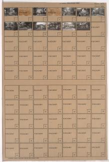
Folder contains photographs of residences in the Westwood neighborhood, from 50th Terrace south to 51st Street, and Westwood Terrace east to Ward Parkway.

Folder contains photographs of residences and other buildings in the Eastern 49-63 neighborhood, from 50th Street south to 50th Terrace, and Lydia Avenue east to Paseo Boulevard.
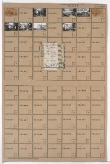
Folder contains photographs of residences and apartment buildings in the Eastern 49-63 neighborhood, from 50th Terrace south to 51st Street, and Lydia Avenue east to Paseo Boulevard. Folder also includes a plat map of the block.

Folder contains photographs of residences in the Blue Hills neighborhood, from 50th Street south to 50th Terrace, and Paseo Boulevard east to Woodland Avenue, including a section of Flora Avenue. Folder also includes a plat map of the block.

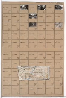
Folder contains photographs of residences in the Blue Hills neighborhood, from 50th Terrace south to 51st Street, and Paseo Boulevard east to Woodland Avenue. Folder also includes a plat map of the block.
Folder contains photographs of residences in the North Town Fork Creek neighborhood, from 50th Street south to 50th Terrace, and Swope Parkway east to Cleveland Avenue. Folder also includes a plat map of the block.

Folder contains photographs of residences and other buildings in the Mount Cleveland neighborhood, from Blue Ridge Road south to 50th Terrace, and Kensington Avenue east to Elmwood Avenue. Folder also includes a plat map of the block.

Folder contains photographs of residences and other buildings in the Mount Cleveland neighborhood, from 50th Terrace south to 51st Street, and Kensington Avenue east to Elmwood Avenue. Folder also includes a plat map of the block.

Folder contains photographs of residences in the Mount Cleveland neighborhood, from Blue Ridge Road south to 50th Terrace, and Jackson Avenue east to Kensington Avenue. Folder also includes a plat map of the block.

Folder contains photographs of residences in the Mount Cleveland neighborhood, from 50th Terrace south to 51st Street, and Kensington Avenue east to Jackson Avenue. Folder also includes a plat map of the block.

Folder contains photographs of residences in the North Town Fork Creek neighborhood, from 50th Terrace south to 51st Street, and Swope Parkway east to Cleveland Avenue. Folder also includes a plat map of the block.