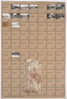
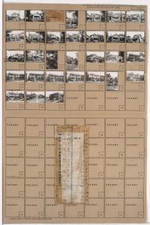
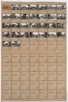
Tax Assessment Block Folder, Kansas City, MO, District 9, Block 42

Folder contains photographs of residences in the Knoches Park neighborhood, from 34th Street south to 35th Street, and Cypress Avenue east to Elmwood Avenue.
Street Names
Folder contains photographs of residences in the Knoches Park neighborhood, from 34th Street south to 35th Street, and Cypress Avenue east to Elmwood Avenue.

Folder contains a photograph of a residence in the Dunbar neighborhood, from 33rd Street south to 34th Street, and Denver Avenue east to Colorado Avenue. Folder also includes a plat map of the block.

Folder contains photographs of residences in the Knoches Park neighborhood, from 33rd Street south to 34th Street, and Cypress Avenue east to Elmwood Avenue. Folder also includes a plat map of the block.

Folder contains photographs of residences in the Knoches Park neighborhood, from 33rd Street south to 34th Street, and Kensington Avenue east to Cypress Avenue. Folder also includes a plat map of the block.

Folder contains photographs of residences in the Knoches Park neighborhood, from 34th Street south to 35th Street, and Kensington Avenue east to Cypress Avenue. Folder also includes a plat map of the block.

Folder contains photographs of residences in the Knoches Park neighborhood, from 34th Street south to 35th Street, and Spruce Avenue east to Kensington Avenue. Folder also includes a plat map of the block.

Folder contains photographs of residences in the Knoches Park neighborhood, from 33rd Street south to 34th Street, and Spruce Avenue east to Kensington Avenue.

Folder contains photographs of residences in the Knoches Park neighborhood, from 33rd Street south to 34th Street, and Jackson Avenue east to Spruce Avenue. Folder also includes a plat map of the block.
Folder contains photographs of residences and other buildings in the Knoches Park neighborhood, from 34th Street south to 35th Street, and Jackson Avenue east to Spruce Avenue. Folder also includes a plat map of the block.

Folder contains photographs of residences, businesses, and apartment buildings in the Palestine West neighborhood, from 34th Street south to 35th Street, and Indiana Avenue east to Bales Avenue. Folder also includes a plat map of the block.

Folder contains photographs of residences in the Palestine East neighborhood, from 33rd Street south to 34th Street, and Mersington Avenue east to Myrtle Avenue.

Folder contains photographs of residences in the Palestine East neighborhood, from 33rd Street south to 34th Street, and Cleveland Avenue east to Mersington Avenue.

Folder contains photographs of residences, businesses, and apartment buildings in the Palestine West neighborhood, from 33rd Street south to 34th Street, and Monroe Avenue east to Cleveland Avenue. Folder also includes a plat map of the block.

Folder contains photographs of residences in the Palestine West neighborhood, from 33rd Street south to 34th Street, and Askew Avenue east to Monroe Street.

Folder contains photographs of residences and apartment buildings in the Palestine West neighborhood, from 33rd Street south to 34th Street, and Bales Avenue east to Askew Avenue. Folder also includes a plat map of the block.
Folder contains photographs of residences, businesses, and apartment buildings in the Palestine West neighborhood, from 33rd Street south to 34th Street, and Indiana Avenue east to Bales Avenue. Folder also includes a plat map of the block.

Folder contains photographs of residences in the Palestine West neighborhood, from 34th Street south to 35th Street, and Askew Avenue east to Monroe Avenue. Folder also includes a plat map of the block.

Folder contains photographs of residences in the Palestine West neighborhood, from 34th Street south to 35th Street, and Monroe Avenue east to Cleveland Avenue.
Folder contains photographs of residences in the Palestine East neighborhood, from 34th Street south to 35th Street, and Cleveland Avenue east to Mersington Avenue.

Folder contains photographs of residences in the Palestine East neighborhood, from 34th Street south to 35th Street, and Mersington Avenue east to Myrtle Avenue. Folder also includes a plat map of the block.