Folder contains photographs of residences in the Walnut Grove neighborhood, from 77th Street south to 77th Terrace, and U.S. Highway 71 (later Hickman Mills Drive) east to Brooklyn Avenue.
Search

Folder contains photographs of residences and apartment buildings in the Valentine neighborhood, from Valentine Road south to 37th Street, and Summit Street (later Southwest Trafficway) east to Jefferson Street. The Roanoke Court Apartments, at 3659-3681 Summit, are among the buildings pictured.

Folder contains photographs of residences and other buildings in the Valentine neighborhood, from 35th Street south to 36th Street, and Summit Street (later Southwest Trafficway) east to Jefferson Street. Norman School, at 3514 Jefferson, is among the buildings pictured.

Folder contains photographs of residences and apartment buildings in the Valentine neighborhood, from 36th Street south to Valentine Road, and Summit Street (later Southwest Trafficway) east to Jefferson Street.

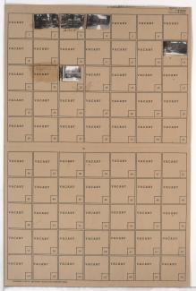
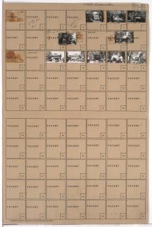
Folder contains photographs of residences in the Coleman Highlands neighborhood, from 31st Street south to 32nd Street, and Karnes Boulevard east to Summit Street (later Southwest Trafficway).

Folder contains photographs of residences, businesses, and apartment buildings in the Valentine neighborhood, from 37th Street south to 38th Street, and Summit Street (later Southwest Trafficway) east to Jefferson Street.
Folder contains photographs of residences, businesses, and apartment buildings in the Valentine neighborhood, from 38th Street south to 39th Street, and Summit Street (later Southwest Trafficway) east to Pennsylvania Avenue. Ritz Ice Cream, at 630 West 39th, is among the buildings pictured.

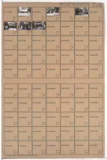
Folder contains photographs of residences in the Coleman Highlands neighborhood, from 32nd Street south to 33rd Street, and Karnes Boulevard east to Summit Street (later Southwest Trafficway).
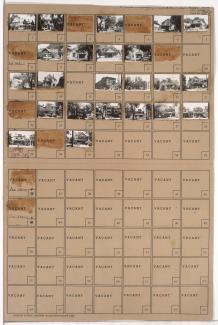
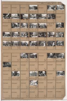
Folder contains photographs of residences in the Coleman Highlands neighborhood, from 35th Street south to Madison Street and 36th Street, and Karnes Boulevard and Madison Avenue east to Summit Street (later Southwest Trafficway).
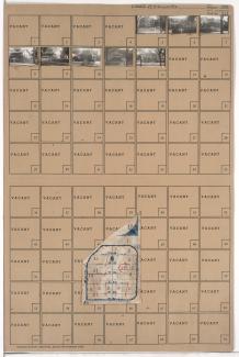
Folder contains photographs of residences in the Roanoke neighborhood, from 36th Street Street south to Valentine Road and Madison Avenue east to Summit Street (later Southwest Trafficway). Folder also includes a plat map of the block.
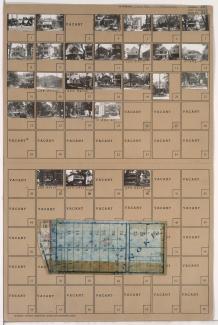
Folder contains photographs of residences and apartment buildings in the Roanoke neighborhood, from Valentine Road south to 37th Street, and Madison Avenue east to Summit Street (later Southwest Trafficway).

Folder contains photographs of residences and apartment buildings in the Roanoke neighborhood, from 37th Street south to 38th Street, and Madison Avenue east to Summit Street (later Southwest Trafficway).
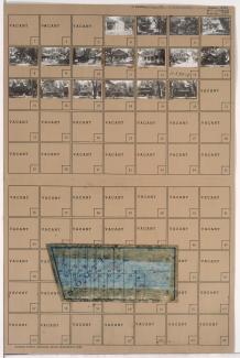
Folder contains photographs of residences, businesses, and other buildings in the Roanoke neighborhood, from 38th Street south to 39th Street, and Roanoke Road east to Summit Street (later Southwest Trafficway). Summit Cleaners, at 800-804 East 39th, is among the buildings pictured.
Street Names
Folder contains photographs of residences and other buildings in the Westport neighborhood, from 39th Street south to 39th Terrace, and Waddell Avenue (later Summit Street, later Southwest Trafficway) east to Pennsylvania Avenue. Adolph Hapke Jewelry Store, at 721 East 39th, and Janoe's Bakery, at 727 West 39th, are among the buildings pictured. Folder also includes a plat map of the block.
Folder contains photographs of residences in the Westport neighborhood, from 39th Terrace south to 40th Street, and Waddell Avenue (later Summit Street, later Southwest Trafficway) east to Pennsylvania Avenue. Folder also includes a plat map of the block.
Folder contains photographs of the St. Joseph's Orphan Home adjacent to Penn Valley Park, from 30th Street south to 31st Street (Karnes Boulevard), and Summit Street (later Southwest Trafficway) east to Pennsylvania Avenue.