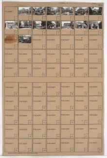
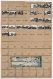
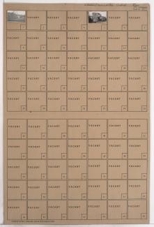
Folder contains photographs of residences in the Beacon Hill neighborhood, from Lake Avenue south to 28th Terrace, and Tracy Avenue east to Paseo Boulevard.
Street Names
Folder contains photographs of residences in the Beacon Hill neighborhood, from Lake Avenue south to 28th Terrace, and Tracy Avenue east to Paseo Boulevard.
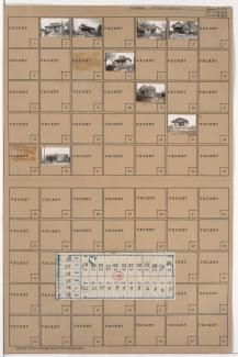
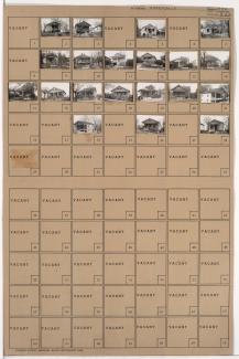
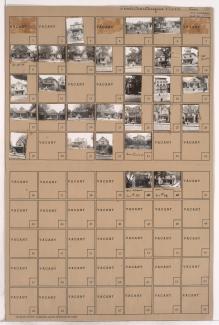
Folder contains photographs of residences in the Beacon Hill neighborhood, from 28th Terrace south to 29th Street, and Tracy Avenue east to Paseo Boulevard.
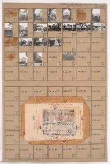
Folder contains photographs of residences and businesses in the South Blue Valley neighborhood, from 28th Terrace south to 29th Street, and Hardesty Avenue east to Oakley Avenue. Folder also includes a plat map of the block.
Folder contains photographs of residences and businesses in the South Blue Valley neighborhood, from Bonita Avenue south to 28th Terrace, and Hardesty Avenue east to Oakley Avenue. Trayford Market, at 2834 Oakley, is among the buildings pictured. Folder also includes a plat map of the block.
Folder contains photographs of residences in the South Blue Valley neighborhood, from Bonita Avenue south to 28th Terrace, and Oakley Avenue east to Topping Avenue. Folder also includes a plat map of the block.
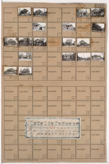
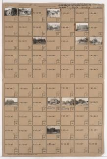
Folder contains photographs of residences in the East Community Team neighborhood, from 28th Street south to 28th Terrace, and Denver Avenue east to Van Brunt Boulevard.
Folder contains photographs of residences in the East Community Team neighborhood, from 28th Terrace south to 29th Street, and Denver Avenue east to Van Brunt Boulevard. Folder also includes a plat map of the block.
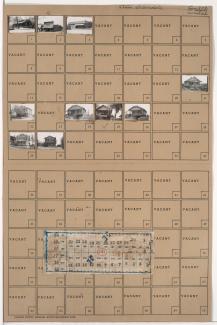
Folder contains photographs of residences in the Greendale neighborhood, from 28th Terrace south to 29th Street, and Oakley Avenue east to Topping Avenue.
First of three folders containing photographs of businesses and industrial buildings in the West Side neighborhood, from 25th Street south to the rail lines, and from the state line and Genessee Street southeast to Southwest Boulevard, including sections of 27th Street, Wyoming Street, 28th Street, and 28th Terrace. Skinmore Home Oil Company, at 2918 Southwest Boulevard, is among the buildings pictured.
Second of three folders containing photographs of residences, businesses, and industrial buildings in the West Side neighborhood, from 25th Street south to the rail lines, and from the state line and Genessee Avenue southeast to Southweast Boulevard, including sections of 27th Street, Wyoming Street, 28th Street, and 28th Terrace. Rodney Milling Company, on Southwest Boulevard, is among the buildings pictured.
Third of three folders containing photographs of industrial buildings in the West Bottoms district, from 25th Street south to the rail lines, and from the state line and Genessee Street southeast to Southweast Boulevard, including sections of 27th Street, Wyoming Street, 28th Street, and 28th Terrace. Folder notes that all images are railroad property, and several Pullman cars can be seen in one image.
Folder contains a photograph of an industrial building in the Northeast Industrial District, from Guinotte Avenue south to the rail lines, and Lexington Avenue east to Vine Street.
Folder contains photographs of an industrial building and a business in the Northeast Industrial District, from Guinotte Avenue south to the rail lines, and Lydia Avenue east to Lexington Avenue.
Folder contains photographs of residences, businesses, and a church in the Walrond Place subdivision, from Anderson Avenue south to Lexington Avenue, and Benton Boulevard east to Indiana Avenue. Assumption Roman Catholic Church, at the corner of Benton Boulevard and Lexington Avenue, is among the buildings pictured.
Folder contains photographs of residences and buildings in the Chautauqua Place addition, from Anderson Avenue south to Lexington Avenue, and Indiana Avenue east to Bales Avenue.
Folder contains photographs of Scarritt Public School, on a block that runs from Anderson Avenue south to Lexington Avenue, and Bales Avenue east to Askew Avenue.
Folder contains photographs of residences in the Chautauqua Place addition, from Anderson Avenue south to Lexington Avenue, and Askew Avenue east to Monroe Avenue.
Folder contains photographs of residences and other buildings in the Chautauqua Place addition, from Lexington Avenue south to Smart Avenue, and Askew Avenue east to Monroe Avenue. Folder also includes a plat map of the block.
Folder contains photographs of residences in the Chautauqua Place addition, from Lexington Avenue south to Smart Avenue, and Bales Avenue east to Askew Avenue. Folder also includes plat map of the block.
Folder contains photographs of residences in the Chautauqua Place addition, from Lexington Avenue south to Smart Avenue, and Indiana Avenue east to Bales Avenue.