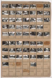
Tax Assessment Block Folder, Kansas City, MO, District 11, Block 284
Folder contains photographs of buildings in the Westport neighborhood, from Westport Road south to 40th Street and east to Baltimore Avenue.
Street Names
Folder contains photographs of buildings in the Westport neighborhood, from Westport Road south to 40th Street and east to Baltimore Avenue.
Folder contains photographs of residences, businesses, and other buildings in the Westport neighborhood, from 39th Street south to Westport Road, and Baltimore Avenue east to Main Street. Foster's Shoes, at Westport and Main, Christmas Barbershop, at 2 Westport Road, and Hyde Park Christian Church, at 39th and Baltimore, are among the buildings pictured. Folder also includes a plat map of the block.
Folder contains photographs of buildings in the Westport neighborhood, from Westport Road south to 40th Street, and Baltimore Avenue east to Main Street. Katz Drugstore, at Westport and Main, is among the buildings pictured. Folder also includes a plat map of the block.

Folder contains photographs of residences, businesses, and other buildings in the Westport neighborhood, from 40th Street south to Westport Road, and Mill Street east to Pennsylvania Avenue. Manor Baking Company, at 4026-4050 Pennsylvania, Sawyer Material & Coal Company, at 530 Westport Road, and Kelly's Westport Inn, at Westport and Pennsylvania, are among the buildings pictured. Folder also includes a plat map of the block.
Folder contains photographs of residences, businesses, and other buildings in the Westport neighborhood, from 39th Terrace south to Westport Road, and Broadway Boulevard and Washington Street east to Central Street, including a section of 40th Street. Westport Laundry Company, at 3954 Central, Wayne's Body & Fender Works, at 4045 Broadway, are among the buildings pictured. Folder also includes a plat map of the block.
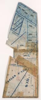
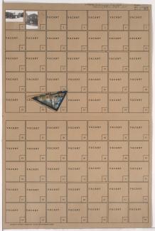
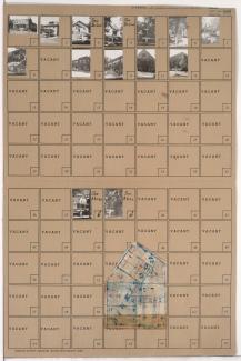
Map of block in the Westport neighborhood, from 40th Street south to Westport Road, and Waddell Avenue east to Mill Street, containing information about tax assessment values of included properties, and illustrating lot numbers for the block. Photographs of properties on the block can be viewed below.
Folder contains photographs of residences and other buildings in the Westport neighborhood, from 40th Street south to Westport Road, and Waddell Avenue east to Mill Street. Kansas City Public Service Company building, at 40th and Waddell, and South Side Wood and Coal Company, at 536 Westport Road, are among the buildings pictured. Folder also includes a plat map of the block, which can be viewed below.

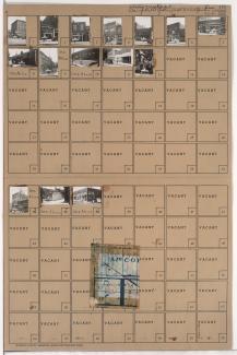
Folder contains photographs of businesses and other buildings in the Westport neighborhood, from Westport Road south to Archibald Avenue, and Mill Street east to Pennsylvania Avenue. Doerschuk's Drug Store, at 501 Westport, is among the buildings pictured. Folder also includes a plat map of the block.
Folder contains photographs of businesses and other buildings in the Westport neighborhood, from 40th Terrace south to Westport Road, and Pennsylvania Avenue east to Washington Street. The Bel-Art Cafe, at 4038 Broadway, Stegner and Stubbs Restaurant, at 406 Westport Road, and K.C. Curtain & Linen Company, at 400 Westport Road, are among the buildings pictured. Folder also includes a plat map of the block.
Folder contains photographs of residences, businesses, and other buildings in the Westport neighborhood, from Westport Road south to Archibald Avenue, and Mill Creek Parkway (later Broadway) east to Central Street. Westport Avenue Bank, at Westport and Mill Creek Parkway, and Broadway Hardware Company, at 311 Westport, are among the buildings pictured. Folder also includes a plat map of the block.
Folder contains photographs of residences and other buildings in the Westport neighborhood, from Westport Road and 40th Street south to Archibald Avenue, and Central Street east to Baltimore Avenue. Westport Assembly of God, at 104-108 Archibald, and Westport Presbyterian Church, at 201 Westport Road, are among the buildings pictured. Folder also includes a plat map of the block.
Folder contains photographs of businesses and other buildings in the Westport neighborhood, from Westport Road south to Archibald Avenue, and Pennsylvania Avenue east to Mill Creek Parkway (later Broadway). Jolly Inn Cafe, at 431 Westport, and Plaza Motors, at 4114-4124 Mill Creek Parkway, are among the buildings pictured. Folder also includes a plat map of the block.

Folder contains photographs of residences in the Westport neighborhood, from 42nd Street south to Westport Road, and Clark Avenue east to Waddell Avenue.

Folder contains photographs of residences in the Westport neighborhood, from Westport Road south to Archibald Avenue, and Clark Avenue east to Jefferson Street.

Folder contains photographs of residences in the Westport neighborhood, from Westport Road south to Archibald Avenue, and Jefferson Street east to Pennsylvania Avenue (later Bridger Road).

Folder contains photographs of residences and businesses in the Westport neighborhood, from Westport Road south to Archibald Avenue, and Roanoke Road east to Clark Avenue. Display Studios sign shop, at 821 Westport Road, is among the buildings pictured. Folder also includes a plat map of the block.
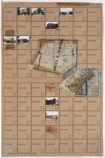
Folder contains photographs of residences, businesses, and other buildings in the Westport neighborhood, from Westport Road south to Archibald Avenue and 42nd Street, and from Pennsylvania Avenue (later Bridger Road) east to Mill Street and Pennsylvania Avenue. Badger Lumber Company, at 557 Westport, is among the buildings pictured. Folder also includes a plat map of the block.
Folder contains photographs of residences, businesses, and other buildings in the Westport neighborhood, from Westport Road south to 43rd Street and east to Roanoke Road, including a section of Archibald Avenue. Westport Pharmacy, at 901 Westport Road, and Bell's Market, at 903 Westport Road, are among the buildings pictured. Folder also includes a plat map of the block.
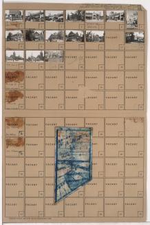
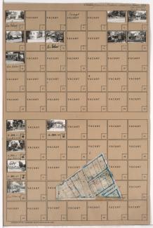
Folder contains photographs of residences, businesses, and apartment buildings in the Volker neighborhood, from 41st Street south to Westport Road, and Roanoke Road east to Clark Avenue. Folder also includes a plat map of the block, which can be viewed below.

Map of block in the the Volker neighborhood, from 41st Street south to Westport Road, and Roanoke Road east to Clark Avenue, containing information about tax assessment values of included properties, and illustrating lot numbers for the block. Photographs of properties on the block can be viewed below.