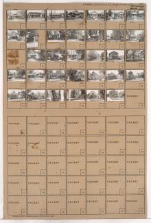
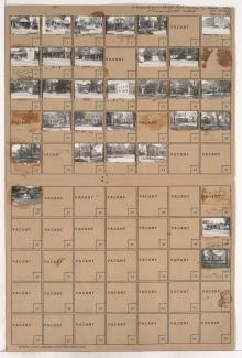
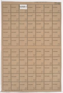
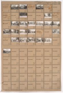
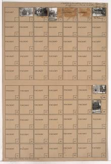
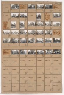
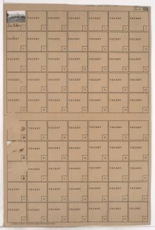
Tax Assessment Block Folder, Kansas City, MO, District 6, Block 23
Folder contains photographs of residences and businesses in the Lykins neighborhood, from 7th Street south to 8th Street, and Van Brunt Boulevard east to Brighton Avenue.
Folder contains photographs of residences in the Lykins neighborhood, from 6th Street south to 7th Street, and Brighton Avenue east to Denver Avenue.
Folder contains photographs of residences in the Lykins neighborhood, from 7th Street south to 8th Street, and Brighton Avenue east to Denver Avenue.
Folder contains photographs of residences in the Lykins neighborhood, from 7th Street south to 8th Street, and Denver Avenue east to Hardesty Avenue.
Folder contains photographs of residences, businesses, and other buildings in the Lykins neighborhood, from 8th Street south to 9th Street, and Van Brunt Boulevard east to Brighton Avenue.
Folder contains photographs of residences and other buildings in the 8th Street south to 9th Street, and Denver Avenue east to Hardesty Avenue.
Folder contains photographs of residences and apartment buildings in the Lykins neighborhood, from 6th Street south to 7th Street, and Denver Avenue east to Hardesty Avenue.
Folder contains photographs of residences and other buildings in the Lykins neighborhood, from 8th Street south to 9th Street, and Brighton Avenue east to Denver Avenue. Gist Cabinet Company, at 9th and Denver, is among the buildings pictured.
Folder contains a photograph of Gulko Auto Wrecking Co., located in an area of Northeast Kansas City bordered by Wilson Avenue on the north and west, Winner Road on the south and east, Bennington Avenue on the east, and including a section of Beacon Avenue.
Folder contains photographs of residences and other buildings in the Lykins neighborhood, from 8th Street south to 9th Street, and Kensington Avenue east to Cypress Avenue.
Folder contains photographs of residences and other buildings in the Lykins neighborhood, from 10th Street south to 10th Terrace, and Cleveland Avenue east to Myrtle Avenue. Beatty Market, at 10th and Cleveland, is among the buildings pictured.
Folder contains photographs of residences in the Lykins neighborhood, from 8th Street south to 9th Street, and Cypress Avenue east to Elmwood Avenue.
Folder contains photographs of residences and businesses in the Lykins neighborhood, from 8th Street south to 9th Street, and Spruce Avenue east to Kensington Avenue. Louis Dry Goods, at 9th and Kensington, is among the buildings pictured.
Folder contains photographs of residences and apartments in the Lykins neighborhood, from 8th Street south to 9th Street, and Myrtle Avenue east to Norton Avenue.
Folder contains photographs of residences and other buildings in the Lykins neighborhood, from 8th Street south to 9th Street, and Cleveland Avenue east to Myrtle Avenue.
Folder contains photographs of residences in the Lykins neighborhood, from 8th Street south to 9th Street, and Norton Avenue east to Spruce Avenue, including a section of Jackson Avenue.
Folder contains photographs of residences and businesses in the Lykins neighborhood, from 9th Terrace south to 10th Street, and Cleveland Avenue east to Myrtle Avenue.
Folder contains photographs of residences and other buildings in the Lykins neighborhood, from 9th Terrace south to 10th Street, and Myrtle Avenue east to Norton Avenue. Holy Trinity Catholic Church and School are among the buildings pictured.
Folder contains photographs of residences in the Lykins neighborhood, from 9th Street south to 9th Terrace, and Cleveland Avenue east to Norton Avenue.
Folder contains a photograph of the Montgomery Ward building at 6220 St. John Avenue, located in an area bordered by Belmont Boulevard/Chouteau Trafficway, St. John Avenue, Norledge Avenue, and Beacon Avenue.