Tax Assessment Block Folder, Kansas City, MO, District 16, Block 114

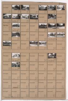
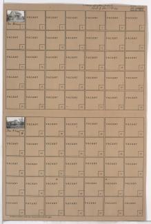
Folder contains photographs of residences in the Walnut Grove neighborhood, from 75th Street south to 76th Street, and Brooklyn Avenue east to Olive Street.
Street Names
Folder contains photographs of residences in the Walnut Grove neighborhood, from 75th Street south to 76th Street, and Brooklyn Avenue east to Olive Street.

Folder contains photographs of residences in the Battleflood Heights neighborhood, from 75th Terrace south to 76th Street, and Lydia Avenue east to Paseo Boulevard.

Folder contains photographs of residences in the Battleflood Heights neighborhood, from 76th Street south to 76th Terrace, and Lydia Avenue east to Paseo Boulevard.

Folder contains photographs of residences in the Battleflood Heights neighborhood, from 75th Terrace south to 76th Street, and Troost Avenue east to Lydia Avenue.
Folder contains photographs of residences and businesses in the Battleflood Heights neighborhood, from 76th Street south to 76th Terrace, and Troost Avenue east to Lydia Avenue.
Folder contains photographs of residences in the Tower Homes neighborhood, from 75th Terrace south to 76th Street, and Harrison Street east to Troost Avenue.
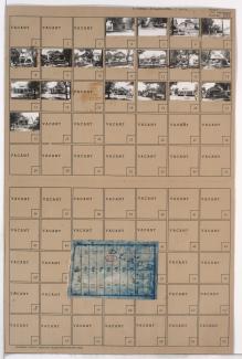
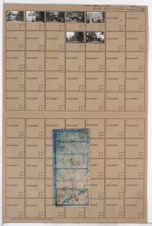
Folder contains photographs of residences in the Rockhill Manor neighborhood, from 76th Street south to 76th Street Terrace, and Campbell Street east to Troost Avenue. Folder also includes a plat map of the block.
Folder contains photographs of residences in the Tower Homes neighborhood, from 75th Street south to 76th Street, and Holmes Road east to Harrison Street, including sections of Charlotte Street and 75th Terrace. Folder also includes a plat map of the block.
Folder contains photographs of residences in the Tower Homes neighborhood, from 76th Street south to 77th Street, and Charlotte Street east to Campbell Street.
Folder contains photographs of residences in the Tower Homes neighborhood, from 76th Street south to 77th Street, and Holmes Road east to Charlotte Street. Folder also includes a plat map of the block.
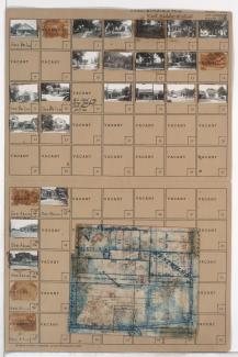
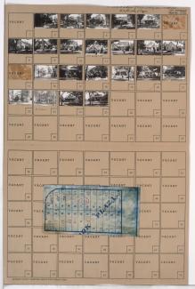
Folder contains photographs of residences and businesses in the Waldo neighborhood, from 75th Street south to 76th Street, and Pennsylvania Avenue east to Wornall Road, including a section of Washington Street. Folder also includes a plat map of the blocks.
Folder contains photographs of residences and other buildings in the Waldo neighborhood, from 76th Street south to 77th Street, and Washington Street east to Wornall Road. Folder also includes a plat map of the block.

Folder contains photographs of residences in the Ward Parkway neighborhood, from 75th Street south to 76th Street, and Jefferson Street east to Pennsylvania Avenue. Folder also includes a plat map of the block.

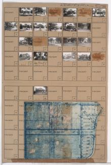
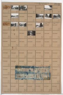
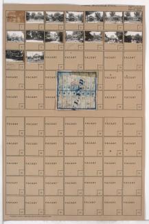
Folder contains photographs of residences in the Ward Parkway neighborhood, from 76th Street south to 77th Street, and Jefferson Street east to Washington Street, including a section of Pennsylvania Avenue. Folder also includes a plat map of the block, which can be viewed below.

Map of block in the Ward Parkway neighborhood, from 76th Street south to 77th Street, and Jefferson Street east to Washington Street, including a section of Pennsylvania Avenue, containing information about tax assessment values of included properties, and illustrating lot numbers for the block. Photographs of properties on the block can be viewed below.

Folder contains photographs of residences in the Ward Parkway neighborhood, from 75th Terrace south to 76th Street, and Summit Street east to Jefferson Street. Folder also includes a plat map of the block.
Folder contains photographs of residences in the Ward Parkway neighborhood, from 76th Street south to 76th Terrace, and Summit Street east to Jefferson Street. Folder also includes a plat map of the block.

Folder contains photographs of residences in the Ward Parkway neighborhood, from 75th Terrace south to 76th Street, and Ward Parkway east to Jarboe Street. Folder also includes a plat map of the block.

Folder contains photographs of residences in the Ward Parkway neighborhood, from 76th Street south to 76th Terrace, and Ward Parkway east to Jarboe Street. Folder also includes a plat map of the block.

Folder contains photographs of residences and other buildings in the Romanelli West neighborhood, from 75th Street south to 77th Street, and State Line Road east to Ward Parkway, including sections of Wyoming and Terrace Streets, 76th Terrace, 76th Street, and 75th Terrace. Folder also includes two plat maps of the block, the second of which can be viewed below.