Tax Assessment Block Folder, Kansas City, MO, District 2, Block 78

Folder contains photographs of residences in an area including Kessler Park, north of Norledge Place and adjacent to Walrond Avenue and Indiana Avenue.
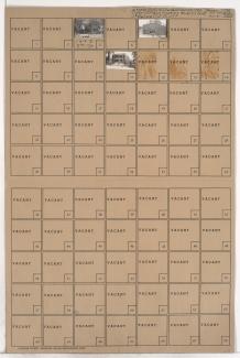
Street Names
Folder contains photographs of residences in an area including Kessler Park, north of Norledge Place and adjacent to Walrond Avenue and Indiana Avenue.

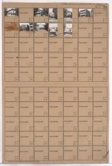
Folder contains photographs of residences in the Pendleton Heights neighborhood, from St. John Avenue south to Pendleton Avenue, and Olive Street east to Wabash Avenue. Folder also contains plat map of the block.
Folder contains photographs of residences in the Pendleton Heights neighborhood, from St. John Avenue south to Pendleton Avenue, and Park Avenue east to Olive Street.
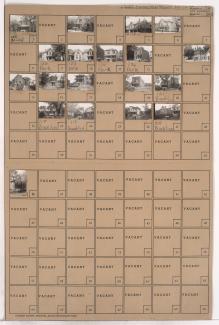
Folder contains photographs of residences in the Pendleton Heights neighborhood, from St. John Avenue south to Pendleton Avenue, and Brooklyn Avenue east to Park Avenue.
Folder contains photographs of residences and apartment buildings in the Pendleton Heights neighborhood, from St. John Avenue south to Pendleton Avenue, and Garfield Place east to Brooklyn Avenue. The Russell H. Pierce residence, at 134 Brooklyn, is among the houses pictured.

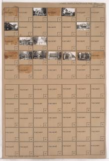
Folder contains photographs of residences in an area adjacent to Kessler Park, from St. John Avenue south to Pendleton Avenue, and Garfield Avenue east to Garfield Place. The John Gilbert residence, at 115 Garfield Avenue, the John I. Standish Residence, at 119 Garfield, and the Morris E. Jones residence, at 135 Garfield Avenue, are among the houses pictured.

Folder contains photographs of residences in an area adjacent to Kessler Park, from the park south to Pendleton Avenue, and the park east to Garfield Avenue. The Flavel B. Tiffany Residence, known as the Tiffany Castle, at 100 Garfield Avenue, and the Philip E. Chappell Residence, at 1836 Pendleton, are among the buildings pictured.
Folder contains photographs of residences in an area adjacent to Kessler Park, bound by Dora Avenue on the northwest, Lexington Avenue on the southwest, and the park on the east. A grain elevator can be seen in the background of one image.

Folder contains photographs of residences in the Pendleton Heights neighborhood, from Lydia Avenue northeast to Lexington Avenue, and Dora Avenue south to 2nd Street.

Folder contains photographs of residences in the Bouton Park addition on Woodland Avenue, surrounded by Kessler Park. Folder also contains a plat map of the area.

Folder contains photographs of residences and apartment buildings in an area of Northeast Kansas City, from 2nd Street and Lexington Avenue south to 3rd Street, and Lydia Avenue east to Highland Avenue.
Folder contains photographs of residences and businesses in Northeast Kansas City, from 4th Street south to 5th Street, and Troost Avenue east to Forest Avenue.

Folder contains photographs of residences and businesses in Northeast Kansas City, from 5th Street south to Pacific Street, and Forest Avenue east to Tracy Avenue. An Italian Evangelical Church, at 505-507 Forest, and Mission, at 1207 5th Street, are among the buildings pictured.

Folder contains photographs of residences and businesses in the Guinotte's Bluff addition, from 5th Street south to Missouri Avenue, and Troost Avenue east to Forest Avenue.

Folder contains photographs of residences and businesses in an area of Kansas City, from Belvidere Avenue south to Independence Avenue, and Tracy Avenue east to Lydia Avenue. Cain Memorial A.M.E. Church, at 595 Tracy, is among the buildings pictured.

Folder contains photographs of residences, businesses, and apartment buildings in an area of Northeast Kansas City, from Pacific Street south to Independence Avenue, and Forest Avenue east to Tracy Avenue. Pete's Barber Shop, at 1204 Independence, is among the buildings pictured.

Folder contains photographs of residences and businesses in the Guinotte's Bluff addition, from Belvidere Avenue south to Independence Avenue, and Troost Avenue east to Forest Avenue. Numerous businesses along Independence Avenue are pictured.

Folder contains photographs of residences and businesses in the Guinotte's Bluff addition, from Pacific Street south to Belvidere Avenue, and Troost Avenue east to Forest Avenue. The Fidelity National Bank building can be seen in the background of an image.

Folder contains photographs of residences and businesses in the Columbus Park neighborhood, from Missouri Avenue south to Pacific Street, and Troost Avenue east to Forest Avenue.